Mansarovar (Jaipur)
Appearance
Mansarovar | |
|---|---|
Neighborhood | |
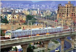
 Metro line near Mansarovar | |
 Location in Jaipur | |
| Coordinates: 26°51′48″N 75°45′59″E / 26.86333°N 75.76639°E | |
| Country | |
| State | Rajasthan |
| District | Jaipur District |
| City | Jaipur |
| Language | |
| • Official | Hindi[1] |
| • Additional official | English[1] |
| Time zone | UTC+5:30 (IST) |
| PIN | 302020 |
| Planning agency | Jaipur Development Authority |
| Civic agency | Jaipur Municipal Corporation |
| Website | jaipur.rajasthan.gov.in |
Mansarovar is a neighborhood in southwest Jaipur, Rajasthan, India. Until 2010,[how?] it was the largest colony in Asia. On June 3, 2015, the Jaipur Metro began serving the area. A large number of people are looking to buy homes in this colony because it has great access to the rest of the city and is located in close proximity to the RIICO Industrial Area, which is recognized as one of the most important employment centers in the region. There are 134,935 people living in Mansarovar.[citation needed] Nine distinct areas make up Mansarovar. The total landmass encompasses around 12.28 square kilometers (4.7 sq mi).
Police stations
[edit]The following police stations of Jaipur police serve this area:
References
[edit]- ^ a b "52nd REPORT OF THE COMMISSIONER FOR LINGUISTIC MINORITIES IN INDIA" (PDF). nclm.nic.in. Ministry of Minority Affairs. Archived from the original (PDF) on 25 May 2017. Retrieved 2 May 2019.
- ^ "Varun Path Police Station".
- ^ "Shipra path Police Station".
