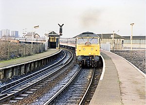
Miles Platting railway station
Miles Platting | |
|---|---|
 Miles Platting railway station in 1989 | |
| General information | |
| Location | Miles Platting, Manchester England |
| Grid reference | SD860000 |
| Platforms | 4 |
| Other information | |
| Status | Disused |
| History | |
| Original company | Manchester and Leeds Railway |
| Pre-grouping | Lancashire and Yorkshire Railway |
| Post-grouping | London, Midland and Scottish Railway |
| Key dates | |
| 1 January 1844 | Opened |
| 27 May 1995 | Closed |
Miles Platting railway station served the district of Miles Platting in Manchester from 1844 until closure on 27 May 1995.[1] The station was opened on 1 January 1844 by the Manchester and Leeds Railway;[2] after amalgamating with other railways, this became the Lancashire and Yorkshire Railway in 1847.[3] The station was situated at the junction of the lines to Stalybridge (opened 1846[4]) and Rochdale (opened 1839[5]), and had platforms on both routes. Little trace remains of the station today, as the platforms were removed and the buildings demolished after closure. However, a length of platform awning has been re-erected at Ramsbottom station on the preserved East Lancs Railway.
References
[edit]- ^ "List of dates from 1 January 1985 to 20 January 2006 of last passenger trains at closed BR (or Network Rail stations since privatisation)" (PDF). Department for Transport Website: Freedom of Information Act responses, February 2006. Department for Transport. 2006. Archived from the original (PDF) on 12 May 2009. Retrieved 5 December 2014.
- ^ Butt 1995, p. 159
- ^ Marshall 1969, p. 65
- ^ Marshall 1969, p. 63
- ^ Marshall 1969, p. 47
- Bairstow, Martin. The Manchester and Leeds Railway.
- Butt, R.V.J. (1995). The Directory of Railway Stations. Yeovil: Patrick Stephens Ltd. ISBN 1-85260-508-1. R508.
- Marshall, John (1969). The Lancashire & Yorkshire Railway, volume 1. Newton Abbot: David & Charles. ISBN 0-7153-4352-1.
- Wells, Jeffrey (June 2004). The Oldham Loop. Foxline. ISBN 1-870119-76-2.
| Preceding station | Historical railways | Following station | ||
|---|---|---|---|---|
| Manchester Victoria Line and station open |
L&YR Caldervale Line |
Newton Heath Line open, station closed | ||
| L&YR Huddersfield Line |
Park Line open, station closed | |||
| Manchester Victoria Line and station open |
L&YR Oldham Loop Line |
Dean Lane Line and station closed | ||
Manchester railways |
|---|
City Centre and North
Past, present and future |
53°29′50″N 2°12′37″W / 53.4971°N 2.2103°W
