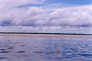
Nanay River
This article is largely based on an article in the out-of-copyright Encyclopædia Britannica Eleventh Edition, which was produced in 1911. (August 2013) |
| Nanay River | |
|---|---|
 The Nanay River (black) meets the Amazon River (light brownish; in background) | |
| Location | |
| Country | Peru |
| Region | Loreto Region |
| Physical characteristics | |
| Mouth | Amazon River |
• coordinates | 3°42′S 73°15′W / 3.700°S 73.250°W |
| Length | 315 km (196 mi) |
| Basin size | 16,673.4 km2 (6,437.6 sq mi)[1] 19,413 km2 (7,495 sq mi)[2] |
| Discharge | |
| • location | Iquitos (near mouth) |
| • average | 930 m3/s (33,000 cu ft/s)
1,072.655 m3/s (37,880.5 cu ft/s)[1] 1,284 m3/s (45,300 cu ft/s)[3] |
The Nanay River is a river in northern Peru. It is a tributary of the Amazon River, merging into this river at the city of Iquitos. The lower part of the Nanay flows to the north and west of the city, while the Itaya River flows to the south and east. Other nearby settlements on the Nanay River include the villages of Santo Tomás, Padre Cocha, and Santa Clara. During periods when the river is low, the many beaches along the Nanay are popular destinations. The Nanay belongs entirely to the lowlands, and is very crooked, has a slow current and divides into many canos[a] and strings of lagoons which flood the flat, low areas of country on either side. It is simply the drainage ditch of districts which are extensively overflowed in the rainy season. Captain Archibald Butt USN, ascended it 195 mi (314 km), to near its source.[4] A part of the Nanay River flows through the Allpahuayo-Mishana National Reserve.
The Nanay is a blackwater river and it has a high fish species richness, including several that are well known from the aquarium industry. Some of these, notably green discus, are the result of accidental introductions that happened in the 1970s.[5][6]
The river is the location of hundreds of illegal artisanal mines digging for gold.[7]
The 2012 floods of the Amazon, Itaya, and Nanay rivers, amid the heaviest rains the region had faced in 40 years, left approximately 80,000 people homeless.[8]
Notes
[edit]References
[edit]- ^ a b "Rivers Network". 2020.
- ^ "Oficina Nacional de Evaluación de Recursos Naturales (ONERN)". 1980.
- ^ "Oficina Nacional de Evaluación de Recursos Naturales (ONERN)". 1980.
- ^ One or more of the preceding sentences incorporates text from a publication now in the public domain: Chisholm, Hugh, ed. (1911). "Amazon". Encyclopædia Britannica (11th ed.). Cambridge University Press.
- ^ Ricketts, M.; and Schlese, D: The Peruvian Altum... it's NOT an Altum, it's Scalare. Retrieved 1 June 2014.
- ^ Aquatechnics: Rio Nanay. Retrieved 1 June 2014.
- ^ Gabay, Aimee (22 December 2023). "'This river is doomed': Peru's gold rush threatens waterways and the people who depend on them". The Guardian. Retrieved 25 December 2023.
- ^ "Inundaciones afectan a unos 80 mil pobladores" [Flooding affects some 80,000 poor]. Perú.21 (in Spanish). 7 April 2012. Archived from the original on 2014-07-31. Retrieved 2016-06-27.

