New Hall Mill
| New Hall Mill | |
|---|---|
 | |
 | |
| General information | |
| Status | Grade II* listed |
| Type | Watermill |
| Location | Wylde Green Road Walmley, West Midlands |
| Coordinates | 52°32′53.520″N 1°48′23.220″W / 52.54820000°N 1.80645000°W grid reference SP 132 945 |
| Website | |
| www | |
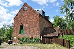
New Hall Mill is a watermill in Walmley, in Sutton Coldfield, West Midlands.
The mill is a Grade II* listed building;[1] it is privately owned, and is managed by the New Hall Water Mill Preservation Trust. It is open to the public on Open Days, or by prior arrangement. It has been restored to working condition, and visitors can see the mill in operation.[2]
The mill is within, but not part of, New Hall Valley Country Park.[2]
Description
[edit]The present structure is a brick building dating from the 18th century; there was an earlier structure, a wing showing remains of timber framing.[1][2] There have been changes of use over time. It originally milled wheat to make flour; more recently, when it could not compete with larger mills, it became a hammermill, powered by a diesel engine, to produce grist or animal feed.[3]
The mill once had two internal waterwheels; it is now powered by an external overshot waterwheel, driving two pairs of millstones. Other machinery in the mill is powered by a Ruston & Hornsby diesel engine.[2]
References
[edit]- ^ a b Historic England. "Newhall Mill (1343322)". National Heritage List for England. Retrieved 24 November 2022.
- ^ a b c d New Hall Mill Retrieved 26 November 2022.
- ^ "Mills of Sutton Coldfield" New Hall Mill. Retrieved 26 November 2022.
