
Nuerland
Nuerland Ro̱l Naath | |
|---|---|
 | |
| Largest city | Bentiu |
| Recognised national languages | Nuer language (Thok Naath) |
| Religion | Christianity (syncretistic or otherwise), Nuer religion |
| Demonym(s) | Nuer people |
| Area | |
• Total | 98,419.5482 km2 (38,000.0000 sq mi) |
| Population | |
• Estimate | 4.5 millions [citation needed] |
| Today part of | part of South Sudan and Ethiopia |
Nuerland (Thok Naath: Ro̱l Naath, Arabic:بلد النوير, Nickname: the True Savannah) is the indigenous homeland and traditional territory of the Nuer people,[1][2] situated largely within South Sudan between the latitudes of 7° and 10° north and longitudes of 29° and 32° east. The region encompasses parts of the Upper Nile State, Jonglei State, Unity State, and surrounding areas, characterized by a mix of swamps, savannahs, and higher ground.
The Nuer are a Nilotic ethnic group primarily engaged in pastoralism, with cattle playing a central role in their economy, social structure, and cultural practices. The landscape of Nuerland, marked by its seasonal floods, dictates the semi-nomadic lifestyle of the Nuer, who move between higher grounds and swampy areas in accordance with the dry and wet seasons.
Historically, the Nuer have had a complex relationship with neighboring ethnic groups, including Dinka people and Shilluk people, and colonial powers, often marked by conflict and competition over resources.
History
[edit]In the early 1800s, the Nuer people undertook various migration and territorial expansion conquests. This expansion was done on various records of raids and displacement on the territory of Dinka and Anyuak.[3]: 1
In the early 1800 AD, Nuer occupied territory of about 8,700 square miles (23,000 km2) located in Western Nile present-day territories of Bul, Leek, Western Jikany, Jagei, and Dok tribes west of River Nile and North of 7°52 N latitude which was surrounded by Dinka on all sides.[3]: 23 By 1890, the Nuer had expanded to the Eastern Nile basin cutting through the center of Dinka territory and a substantial portion of Anyuak country to the far east of Ethiopia escarpment.[4][page needed][5]
At the beginning of the 19th century, the Nuer expanded their territory to about 35,000 square miles (91,000 km2).[3]: 1 This successful territorial gain was accomplished in a short span of about sixty years, during the period between 1820 and 1880. Exogenous factors such as the Abyssinia territorial conquest and the Ottoman Empire invasion of North Sudan in 1821 and 1827 subsequently brought the Nuer expansion to a halt.[6]
The 19th century Nuer territorial expansion was done on two principal movements by two men: Latjor who led the Jikany, and Bidiet who led the Lou. These two men have no political status or ritual qualification; but are renowned warriors who possess outstanding leadership, prowess, and the ability to stir up youth enthusiasm for a raid.[7] First the migration of Jikany to the far east toward the Sobat River and as far as the Ethiopian border more than hundreds of miles away from the Nuer homeland. The Jikany first migrated Northward to Jebel El Liri on the border of Nuba territory then turned eastward along the border area between Nuba and Shilluk. There, they fought and defeated Reth Awin, the king of Shilluk. They then cut across the Shilluk territory in the vicinity of Melut and crossed the Nile during the dry season into northern Dinka territory. They fought the Dinka there and captured many of their cattles and then turned South and proceeded to the lower Sobat River. They settled temporarily in the area of Abwong and then pushed upstream along both sides of Sobat to their present territory.[3][page needed]
The second wave of Nuer expansion was spearheaded by Lou Nuer and Gawaar that proceeded through the heart of central Dinka territory. Lou Nuer went as far as due east to the border of the eastern Jikany enclave. This movement began not long after the commencement of the Jikany migration and it was described as the "twin migration" in the Nuer conquest to extend their territory. Gaawar who originally occupied the Southern part of Dok territory migrated to their present home by just crossing the Nile and settling in one of the vast swampy regions in the world, the Sudd. Lou Nuer who originally lived and shared territory with Jagei crossed the Nile at about fifty miles north within the same period and settled in the presence territory of Lak and Thiang Nuer. Another Nuer territorial expansion that followed the Twin Migration was the Lak and Thiang Nuer migration. They crossed the Nile and moved north of Zeraf island shortly after Lou Nuer moved further east to the border of eastern Jikany and southward. Zeraf Island was originally conquered by Lou Nuer. These two movements took place independently.[3]: 33
While the Eastern Jikany, Lou, Gawaar, Lak, and Thiang were expanding the Nuer territory east of the Nile, Nyoung Nuer in 1845 to 1876 moved South along the west side of the Nile displacing and pushing Shish Dinka further South. This marked the end of Western Nuer (homeland) territorial expansion in the west of the Nile but on the other side of the Nile, the Nuer territorial expansion continued until the early 2000s. The other small Nuer expansion which did not see much success was the homeland Nuer (Western Nuer) expansion toward the West and the North. The failure of the Westward and Northward expansion was not surprising given the fact that a large area of the Nuer homeland was vacated by Eastern Jikany, Lou, Gawaar, Lak, and Thiang.[3][page needed][8]
According to the colonial record archived in England and Sudan, there were 26 raids by the Nuer against Dinka recorded between 1905 and 1928. Some of these reports document the widespread devastation caused by the large-scale Nuer raids as well as clarify the role that these raids played in the Nuer territorial expansion. It also outlines the broad Nuer military organization, tactics, and foray into Dinka territory. This expansion was partly accomplished by the occupation of areas in which the Dinka had withdrawn as a result of recurrent Nuer raids and partly through the Nuer assimilation of Dinka when Latjor led Jikany out of Bentiu to their present land. The vast territory conquered by the Nuer in the 19th century was previously occupied by Dinka and Anyuak.[3][page needed]
A recent archeological study suggests that Nuer people have lived around the Nile Valley region since around 3372 B.C.E.[9]
These territorial expansions divided the Nuer into three tribal groups:
- The Western Nuer (Homeland Nuer) includes; Bul, Leek, Western Jikany, Jagei, Dok, Nyoung, Haak.
- The Central Nuer includes Fangak Nuer and Lou Nuer. Fangak Nuer: Lak, Thiang, and Gawaar. Lou Nuer; Guun, and Mor.
- The Eastern Nuer are the Eastern Jikany Nuer; Gajiok, Gajaak, and Gagaung.[3][page needed]
Nuerland counties
[edit]Nuerland is largely located within South Sudan and some parts of western Ethiopia.[10][11] Nuerland covers a total land area of 38,000 square miles (98,419.55 square kilometers).[11] Nuerland is home to the Sudd, one of the largest swampy regions in the world.[12] The passing of the River Nile across the Nuerland split the Nuer into two parts, the western part of the Nuer region (Nuer Homeland) and the Eastern part of the Nuer region (Central Nuer and Eastern Nuer).[13] Nuerland set in the open savannah, thornwood forests, and extensive marshlands on both sides of the Nile where it earned its name the true savannah.[14]
Nuerland bordered Dinka to the West, Shilluk, and Dinka to the North, Burun to the North East, Anyuak and Ethiopia to the East, Murle to the South East, and Dinka to the South.[4] The main characteristics of Nuer land are that it's flat land, it's subject to heavy rain in the wet season, all its rivers flood in the rainy season, it's covered with high grasses in the wet season, and when the rain ceases and the rivers fall, it is subject to drought.[14][15]
Nuerland constitutes 16 of 79 counties which make up the 10 states of South Sudan according to South Sudan counties distribution and 7 of 13 Woredas of Gambella, Ethiopia. Four counties in Upper Nile State, five in Jonglei State, and seven counties in Unity State, all of which are located in the Greater Upper Nile region. In the Gambella region, Ethiopia, five woredas are located in the Nuer Zone while two are shared zones with Anyuak and Ethiopian Highlanders.[16]
| County | Payam |
|---|---|
| Nasir/Kuanylualthuan | 1- Nasir(County HQ) 2. Dhorading 3. Dinkar 4. Kech Kun 5.Gai Reang 6. Roam 7.Koat 8. Kierwan 9. Jikmir
10. Kuetrengke 11. Wanding 12. Mading 13. Maker 14. Gurnyang 15. Wechnyot.[17][18] |
| Ulang | 1- Ulang(County HQ) 2. Doma 3. Yomding 4. Kurmuot 5. Nyangore 6. Ying 7. Barmach 8. Kerchot 9. Torbaar 10.Riek-Kueh[19] |
| Longechuk | 1- Mathiang(County HQ) 2. Dajo 3. Guelguk 4. Jangok 5. Malual 6. Pamach 7. Wudier.[20] |
| Maiwut | 1- Maiwut(County HQ) 2. Kigile 3. Jekow 4. Jotoma 5. Uleng 6. Pagak 7. Wuor 8. Malek 9. Turuu.[21] |
| Fangak | 1- Old Fangak(County HQ) 2. Phom/New Fangak 3. Paguir 4. Manajang 5. Mareang.[22][23] |
| Ayod | 1- Ayod (County HQ) 2. Kurwai 2. Mogok 3. Kuach-deng 4. Wau 5. Pagil 6. Pajiek.[24] |
| Uror | 1- Yuai (County HQ) 2. Puolchoul 3. Tiam 4. Karam 5. Pamai 6. Motot 7. Pathai 8. Payai 9. Pieri.[25][26] |
| Nyirol | 1- Waat(County HQ) 2. Thol 3. Chuil 4. Nyambor 5. Pulturuk 6. Pading.[27][28] |
| Akobo | 1- Bilkey(County HQ) 2. Allali 3. Buong 3. Kuonykew 4. Walgak 5. Deng Jok 6. Diror 7. Nyandit.[29][30] |
| Mayom | 1- Mayom(County HQ) 2. Bieh 3. Wangkei 4. Kuerbuone 5. Mankien 6. Kueryiek 7. Ngop 8. Pup 9. Riak 10. Ruathnyibuol 11. Riak 12. Wangbuor-1 13. Wangbuor-2 14. Wangbuor-3.[31] |
| Rubkona | 1- Rubkona(County HQ) 2. Dhorbor 3. Bentiu 4. Budaang 5. Wathjaak 6. Kaljak 7. Ngop 8. Nhialdiu 9. Panhiany.[32][33] |
| Guit | 1- Guit(County HQ) 2. Wathnyona 3. Kedad 4. Nyathoar 5. Kuac 6. Kuerguini 7. Niemni 8. Bil 9. Nying.[34] |
| Koch | 1- Kuachlual(County HQ) 2. Boaw 3. Pakur 4. Ngony 5. Gany 6. Jaak 7. Norbor.[35][36] |
| Mayiandit | 1- Mayiandit(County HQ) 2. Tutnyang 3. Dablual 4. Thaker 5. Leah 6. Maal 7. Pabuong 8. Tharjiathbor 9. Rubkuay, 10. Bhor, 11. Jaguar, 12. Madol 1, 13. Madol 2, 14. Mirnyal.[37][38] |
| Leer | 1- Leer(County HQ) 2. Bou 3. Thonyor 4. Guat 5. Juong Kang 6. Padeah 7. Pilieny 8. Yang.[39] |
| Panyijiar | 1- Panyijiar(County HQ) 2. Ganyiel 3. Kol 4. Mayom 5. Nyal 6. Pachaar 7. Pachak 8. Pachienjok 9. Thoarnhoum 10. Tiap.[40] |

| County(Woreda) | Payam |
|---|---|
| Jokow woreda | |
| Lare Woreda | |
| Akobo Woreda | |
| Wanthoa Woreda | |
| Makuey Woreda | |
| Gambella Zuria(shared with Anyuak)[41] | |
| Itang Special Woreda(shared with Anyuak)[42] |
Vegetation and climate
[edit]Nuerland climate can highly be described as tropical climate for it has two major seasons, Wet and dry season. Although these two seasons define Nuerland climate, there are still four seasons that dictate Nuer people's activity, Summer, Spring, Autumn, and Winter. Nuerland vegetation is characterized by grassland savannah, woodland savannah, and forestry consisting mainly of Acacia trees which is the largest producer of gum arabic, lalob trees (desert dates), Tamarind trees which produce the most sour tamarind in the world, some neem trees, some baobab trees, some palm trees, and some native Nuerland plant species. These forestry, grassland, and woodland savannahs are natural habitats for Nuerland wildlife which include, Elephants, Girafe, Lion, Tiger, Leopard, Buffalo, Hyena, fox, serval, monkeys, Rhino, and Antelope; mostly Gazelle.[citation needed]
Nuerland ecosystem features consist of Rivers, marshes, large swampy areas, and numerous fishing ponds. This Nuerland ecosystem provides a habitat for invertebrates, fish, amphibians, waterfowl, and an array of flora and fauna.[citation needed]
Nuerland geomorphology is broadly made up of extensive flatland savannah which contains largely loam soil, some clay soil, silt soil, and a small amount of sandy soil. The physical features of Nuerland make it one of the most lucrative rich Agricultural land in East Africa.[43]
Livestock and agriculture
[edit]Nuerland inhabitants' economic necessity is mainly surrounded around Agriculture, Animal husbandry, fishing, and hunting. Nuer are mainly regarded as pastoral people with dominant pastoral interests and do not necessarily feel bound by economic necessity.[3] They migrated and spent the whole dry season in cattle and fishing camps around the swampy areas, fishing ponds, and rivers, and returned to their villages at the end of the dry season where they began to cultivate their farms. Maize, millet, and sorghum are their main crops followed by beans, pumpkin, Okra, and tobacco.[4][page needed]
Nuer people's livestock are mainly cows, goats, and sheep. Nuer's lives vastly evolved around their cattle since time immemorial. They are deeply connected to their cows especially the Oxen, physically, emotionally, and spiritually. Each Nuer man knows the character and the habits of all his oxen. A Nuer man usually gets a boy to lead his favorite oxen around the cattle camps in the morning as he leaps and sings behind it. In the evening when the ox comes home, he pets it, rubs ashes on its back, removes ticks from its scrotum and belly, and picks adherent dunk from its anus. He tethers his ox in front of his windscreen so he can see it when he wakes in the morning, for no sight fills a Nuer man with contentment and pride as his oxen. To make his ox more attractive, he decorates its horn with long tassels which he admires as the ox tosses its head when walking. The more he can display his ox, the happier he is.[3][page needed]
Cattle make up a large portion of Nuer people's livestock while sheep and goats make up a small portion. Although cattle held extremely significant importance to the Nuer people's lives, sheep and goats held significant value to the Nuer as well. Nuer people do not raise livestock for meat, but bulls and sheep are slaughtered when there is an important occasion.[44][45]
Resources
[edit]Nuerland is rich in natural resources. It has been the anchor of South Sudan's economy since its independence from Sudan. These natural resources include oil, untapped potential of natural gas, water resources, wildlife, and fisheries.[citation needed]
Oil which is mostly produced in Western Nuer Homeland has been the cornerstone of South Sudan's economy making up at least 80% of the country's annual income since its discovery in 1978 by Chevron.[46]
Nuerland alone accounts for more than 80% of South Sudan's economy despite being largely devastated by the war and extremely underdeveloped.[47]
Gallery
[edit]-
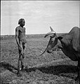 Nuer man and his ox.
 -
 Ngundeng Pyramid located in Wech Deng village, Nyirol County 1901.


References
[edit]- ^ Jek, Bol J. (2018-11-04). The Nuer State: Röl Nath. Uganda National Library. ISBN 978-9970-9711-2-1.
- ^ "AFRICA | 101 Last Tribes - Nuer people". www.101lasttribes.com. Retrieved 2024-06-12.
- ^ a b c d e f g h i j Kelly, Raymond C. (1985-08-30). The Nuer Conquest: The Structure and Development of an Expansionist System. Ann Arbor, Mich: University of Michigan Press. ISBN 978-0-472-08056-4.
- ^ a b c Evans-Pritchard, E. E. (1940-01-01). The Nuer: A Description of the Modes of Livelihood and Political Institutions of a Nilotic People. Pantianos Classics. ISBN 978-1-78987-318-4.
- ^ People, Nuer. "Nuer People of South Sudan". study.com. Retrieved 2024-06-12.
- ^ Johnson, Douglas H. (1997-05-01). Nuer Prophets: A History of Prophecy from the Upper Nile in the Nineteenth and Twentieth Centuries (Revised ed.). Oxford: Clarendon Press. ISBN 978-0-19-823367-1.
- ^ "Sudan Notes and Records Volume 32 — Sudan Open Archive". sudanarchive.net. Retrieved 2024-06-08.
- ^ Jock, George Gatluak. The Unique Background of the Nuer Nation.
- ^ "The Nuer People of South Sudan | Language, Facts & Traditions". study.com. Retrieved 2024-06-07.
- ^ "eHRAF World Cultures". ehrafworldcultures.yale.edu. Retrieved 2024-06-12.
- ^ a b "Nuer | Encyclopedia.com". www.encyclopedia.com. Retrieved 2024-06-12.
- ^ Jek, Bol Jok; D, Deng Vanang (2021-02-04). THE HISTORY OF NUER NATION 5000 BCE TO 1943: CAALLI ROLNATH. Independently published. ISBN 979-8-7047-1161-2.
- ^ Beswick, Stephanie (2004). Sudan's Blood Memory: The Legacy of War, Ethnicity, and Slavery in Early South Sudan. University Rochester Press. ISBN 978-1-58046-151-1.
- ^ a b "Sudan Notes and Records Volume 21 — Sudan Open Archive". sudanarchive.net. Retrieved 2024-06-08.
- ^ Huffman, Ray; Westermann, D. (1931). Nuer customs and folklore. International Institute of African Language and Culture.
- ^ "Zones and Woredas". Gambella Vision. Retrieved 2024-06-25.
- ^ "Luakpiny/Nasir". csrf-southsudan. Retrieved 2024-06-16.
- ^ "UNMISS skills communities in Nasir on improving relations with uniformed personnel". UNMISS. 2024-05-15. Retrieved 2024-06-16.
- ^ "Ulang". csrf-southsudan. Retrieved 2024-06-16.
- ^ "Longochuk". csrf-southsudan. Retrieved 2024-06-16.
- ^ "Maiwut". csrf-southsudan. Retrieved 2024-06-16.
- ^ "Fangak". csrf-southsudan. Retrieved 2024-06-16.
- ^ "South Sudan Fangak County reference map (As of March 2020) - South Sudan | ReliefWeb". reliefweb.int. 2020-03-30. Retrieved 2024-06-16.
- ^ "Ayod". csrf-southsudan. Retrieved 2024-06-16.
- ^ "Uror". csrf-southsudan. Retrieved 2024-06-16.
- ^ "South Sudan Uror County reference map (As of March 2020) - South Sudan | ReliefWeb". reliefweb.int. 2020-03-30. Retrieved 2024-06-16.
- ^ "Nyirol". csrf-southsudan. Retrieved 2024-06-16.
- ^ "South Sudan Nyirol County reference map (As of March 2020) - South Sudan | ReliefWeb". reliefweb.int. 2020-03-30. Retrieved 2024-06-16.
- ^ "Akobo". csrf-southsudan. Retrieved 2024-06-16.
- ^ "South Sudan Akobo County reference map (As of March 2020) - South Sudan | ReliefWeb". reliefweb.int. 2020-03-30. Retrieved 2024-06-16.
- ^ "Mayom". csrf-southsudan. Retrieved 2024-06-16.
- ^ "Rubkona". csrf-southsudan. Retrieved 2024-06-16.
- ^ "South Sudan: Rubkona County reference map (As of March 2020) - South Sudan | ReliefWeb". reliefweb.int. 2020-03-31. Retrieved 2024-06-16.
- ^ "Guit". csrf-southsudan. Retrieved 2024-06-16.
- ^ "Koch". csrf-southsudan. Retrieved 2024-06-16.
- ^ "South Sudan: Koch County reference map (As of March 2020) - South Sudan | ReliefWeb". reliefweb.int. 2020-03-31. Retrieved 2024-06-16.
- ^ "Mayendit". csrf-southsudan. Retrieved 2024-06-16.
- ^ "South Sudan Mayendit County reference map (As of March 2020) - South Sudan | ReliefWeb". reliefweb.int. 2020-03-30. Retrieved 2024-06-16.
- ^ "Leer". csrf-southsudan. Retrieved 2024-06-16.
- ^ "Panyijiar". csrf-southsudan. Retrieved 2024-06-16.
- ^ GCDC (2016-08-22). "Gambella Profile". gambellacommunity.org. Retrieved 2024-06-15.
- ^ "Zones and Woredas". Gambella Vision. Retrieved 2024-06-15.
- ^ Jock, George Gatluak (2019-04-09). The Unique Background of the Nuer Nation. Independently published. ISBN 978-1-0929-9885-7.
- ^ "Nuer Dilemmas: Coping With Money, War, And The State (2023 Edition) | Mystery to Me : An Independent Bookstore". www.mysterytomebooks.com. Retrieved 2024-06-06.
- ^ Hutchinson, Sharon (May 1992). "the cattle of money and the cattle of girls among the Nuer, 1930–83". American Ethnologist. 19 (2): 294–316. doi:10.1525/ae.1992.19.2.02a00060. ISSN 0094-0496.
- ^ "Block 5A - Oil field of Sudan - Massive changes". www.prinsengineering.com. Retrieved 2024-06-06.
- ^ "Austrian OMV to acquire interest Block 5A in Sudan — Alexander's Gas and Oil Connections". 2012-03-23. Archived from the original on 2012-03-23. Retrieved 2024-06-06.