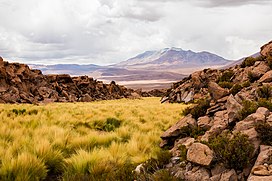
Olca
| Olca | |
|---|---|
 | |
| Highest point | |
| Elevation | 5,407 m (17,740 ft) |
| Coordinates | 20°56′0″S 68°29′0″W / 20.93333°S 68.48333°W |
| Geography | |
| Location | Bolivia, Nor Lípez Province, San Pedro de Quemes Municipality, Cana Canton Chile, Antofagasta Region, El Loa Province |
| Parent range | Andes |
| Geology | |
| Mountain type | Stratovolcano |
| Last eruption | 1867 |
Olca is a stratovolcano on the border of Chile and Bolivia. It lies in the middle of a 15 km long ridge composed of several stratovolcanos. Cerro Minchincha lies to the west and Paruma to the east. It is also close to the pre-Holocene Cerro Paruma. It is andesitic and dacitic in composition, with lava flows extending several kilometres north of the peak. The only activity from the ridge during historical times was a flank eruption from 1865 to 1867. The exact source of this eruption is unclear.
Gas emissions and composition
[edit]The gasses emission is comprised by a single warm spring at the base[1] and a persistent fumarole field over at the crater's dome for at least 60 years.[2] The fumarolic field is about 0.1 km2 and the emissions measured in situ at the crater show a highly mixed magmatic system between high temperature temperature gasses and hydrothermal fluids.
The gas composition indicates low concentration of H2, CO and acidic gasses, and high concentration of H2S and hydrocarbons.[2] The carbon/sulfur ratios are high and the isotopic values suggest the mixture between magmatic, hydrothermal, and atmospheric fluids.[2] Other techniques used to measure the amount of SO2 includes remote sensing techniques called Differential Optical Absorption Spectroscopy(DOAS) giving maximum concentration of 35 ppm.m of SO2;[3] and the most recent taken with a UV camera suggesting an average of 18.4 t d−1.[4]
Eruptive history and latest activity
[edit]Different information exists regarding the activity and activity migration of Olca. There is a study dating two flows, which suggest a formation during the Pleistocene,[5] while others suggest to be much older with the appearance of the edifices volcanic activity migrated east over time.[6] There is also evidence that glaciers were on the volcano in the late Pleistocene.[6] The
Unconfirmed historical eruptions are suspected to have occurred in 1865–1867.[7] The last activity has been reported of low-intensity seismicity accompanied with fumarolic activity in November 1989 and March 1990 intense degassing.[8] In 2010, there a campaign conducted seismic activity showing 3 potencial swarms without a clear interpretation.[7]

See also
[edit]References
[edit]- ^ Reyes, Nicolas. "Geothermal Exploration at Irruputuncu and Olca Volcanoes: Pursuing a Sustainable Mining Development in Chile". Geothermal Resources Council Transactions: 35.
- ^ a b c Franco Tassi; Felipe Aguilera; Orlando Vaselli; Thomas Darrah; Eduardo Medina (2011-06-30). "Gas discharges from four remote volcanoes in northern Chile (Putana, Olca, Irruputuncu and Alitar): a geochemical survey". Annals of Geophysics. 54 (2). doi:10.4401/ag-5173.
- ^ Clavero J., Soler V., Amigo A. 2006. Caracterización preliminar de la actividad sísmica y de desgasificación pasiva de volcanes activos de Los Andes Centrales del Norte de Chile. XI Congreso Geológico Chileno, Actas II, 443-446 (Spanish)
- ^ Aguilera, Felipe; Layana, Susana; Rojas, Felipe; Arratia, Pilar; Wilkes, Thomas C.; González, Cristóbal; Inostroza, Manuel; McGonigle, Andrew J.S.; Pering, Tom D.; Ureta, Gabriel (2020-07-02). "First Measurements of Gas Flux with a Low-Cost Smartphone Sensor-Based UV Camera on the Volcanoes of Northern Chile". Remote Sensing. 12 (13): 2122. Bibcode:2020RemS...12.2122A. doi:10.3390/rs12132122. ISSN 2072-4292.
- ^ Worner, Gerhard; Hammerschmidt, Konrad; Henjes-Kunst, Friedhelm; Lezaun, Judith; Wilke, Hans. "Geochronology (40Ar/39Ar, K-Ar and He-exposure ages) of Cenozoic magmatic rocks from Northern Chile (18-22°S): Implications for magmatism and tectonic evolution of the Central Andes". Revista Geológica de Chile. 27: 205–240.
- ^ a b "Olca & Paruma". volcano.oregonstate.edu. Retrieved 2021-12-10.
- ^ a b Pritchard, M.E.; Henderson, S.T.; Jay, J.A.; Soler, V.; Krzesni, D.A.; Button, N.E.; Welch, M.D.; Semple, A.G.; Glass, B.; Sunagua, M.; Minaya, E. (June 2014). "Reconnaissance earthquake studies at nine volcanic areas of the central Andes with coincident satellite thermal and InSAR observations". Journal of Volcanology and Geothermal Research. 280: 90–103. Bibcode:2014JVGR..280...90P. doi:10.1016/j.jvolgeores.2014.05.004.
- ^ "Global Volcanism Program | Report on Olca-Paruma (Chile-Bolivia) — March 1990". volcano.si.edu. doi:10.5479/si.gvp.bgvn199003-355050. Retrieved 2021-12-10.

