Päijänne National Park
Appearance
| Päijänne National Park | |
|---|---|
 Päijätsalo island on the right belongs to the national park | |
| Location | Päijänne Tavastia, Finland |
| Coordinates | 61°23′12″N 25°23′36″E / 61.38667°N 25.39333°E |
| Area | 14 km2 (5.4 sq mi) |
| Established | 1993 |
| Visitors | 15000 (in 2009[1]) |
| Governing body | Metsähallitus |
| Website | www |
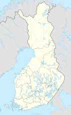
Päijänne National Park (Finnish: Päijänteen kansallispuisto) is a national park in Finland, in the southern parts of Lake Päijänne. It consists of 50 unbuilt islands and parts of inhabited islands. The national park was established in 1993 and has an area of 14 square kilometres (5.4 sq mi).
See also
[edit]References
[edit]- ^ "Käyntimäärät kansallispuistoittain 2009" (in Finnish). Metsähallitus. Retrieved September 29, 2010.
External links
[edit]

