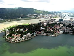
Penha Hill
Appearance
| Penha Hill | |
|---|---|
| Colina da Penha | |
 | |
| Highest point | |
| Elevation | 62.7 m (206 ft) |
| Coordinates | 22°11′11.3″N 113°32′5.0″E / 22.186472°N 113.534722°E |
| Naming | |
| Native name | 西望洋山 (Chinese) |
| Geography | |
 | |
| Location | São Lourenço, Macau (special administrative region of the PRC) |
| Geology | |
| Mountain type | hill |
| Penha Hill | |||||||||||
|---|---|---|---|---|---|---|---|---|---|---|---|
| Chinese | 西望洋山 | ||||||||||
| |||||||||||
The Penha Hill (Chinese: 西望洋山; Portuguese: Colina da Penha) is a hill in São Lourenço, Macau, China.
Geology
[edit]At an elevation of 62.7 meters (206 ft) above sea level, the hill is the third highest hill in Macau.[1] On its slope, lays many pieces of granites.[2]
Features
[edit]At the top of the hill stands the Our Lady of Penha Chapel.[3] There are also markets, hotels and restaurants around the hill.[4]
See also
[edit]References
[edit]- ^ "Penha Hill in Macau". China Dragon Tours. Retrieved 21 October 2021.
- ^ "Penha Hill". VisitOurChina. Retrieved 16 February 2022.
- ^ "Penha Hill". Lonely Planet. Retrieved 21 October 2021.
- ^ "Penha Hill in Macau". Cultural China. Retrieved 16 January 2017.[permanent dead link]
Wikimedia Commons has media related to Penha Hill.
