
Portal:Kent/Sandbox
DesktopMobile
Test of: Transclude files as random slideshow/sandbox
-
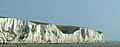 The White Cliffs of Dover (from Kent)
 -
 Geological cross-section of Kent, showing how it relates to major towns (from Kent)
 -
-
 Canterbury Cathedral (from Kent)
 -
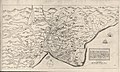 A map of Romney Marsh "The history of imbanking and drayning" by William Dugdale (1662). (from Kent)
 -

-

-

-
-
 Hand-drawn map of Kent, Sussex, Surrey and Middlesex from 1575. (from Kent)
 -
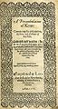 Title page of William Lambarde's Perambulation of Kent (completed in 1570 and published in 1576), a historical description of Kent and the first published county history (from Kent)
 -
 The coat of arms of Kent County Council (from Kent)
 -
-
 An early mention of Kent in the Anglo-Saxon Chronicle between 11th and 12th centuries (from Kent)
 -
 View of the White Cliffs of Dover from France (from Kent)

Apr2006.jpg)

.jpg)


Test of: Transclude linked excerpts as random slideshow/sandbox
-
 Portsmouth (/ˈpɔːrtsməθ/ PORTS-məth) is a port city and unitary authority in Hampshire, England. Most of Portsmouth is located on Portsea Island, off the south coast of England in the Solent. This means Portsmouth is the only English city not located primarily on the mainland. Located 74 miles (119 km) south-west of London, 50 miles (80 km) west of Brighton and Hove, and 22 miles (35 km) south-east of Southampton; Portsmouth is part of the South Hampshire conurbation. It is the most densely populated city in the United Kingdom, with a population last recorded at 208,100. (Full article...)
 -
Sevenoaks is a local government district in west Kent, England. Its council is based in the town of Sevenoaks. (Full article...)
-
Folkestone (/ˈfəʊkstən/ FOHK-stən) is a port town on the English Channel, in Kent, south-east England. The town lies on the southern edge of the North Downs at a valley between two cliffs. It was an important harbour, shipping port and fashionable coastal resort for most part of the 19th and mid 20th centuries. (Full article...)
-
Hops are the flowers (also called seed cones or strobiles) of the hop plant Humulus lupulus, a member of the Cannabaceae family of flowering plants. They are used primarily as a bittering, flavouring, and stability agent in beer, to which, in addition to bitterness, they impart floral, fruity, or citrus flavours and aromas. Hops are also used for various purposes in other beverages and herbal medicine. The hops plants have separate female and male plants, and only female plants are used for commercial production. The hop plant is a vigorous, climbing, herbaceous perennial, usually trained to grow up strings in a field called a hopfield, hop garden (in the South of England), or hop yard (in the West Country and United States) when grown commercially. Many different varieties of hops are grown by farmers around the world, with different types used for particular styles of beer. (Full article...)
-
Westerham is a town and civil parish in the Sevenoaks District of Kent, England. It is located 3.4 miles east of Oxted and 6 miles west of Sevenoaks, adjacent to the Kent border with both Greater London and Surrey.
It is recorded as early as the 9th century, and was mentioned in the Domesday Book in a Norman form, Oistreham (compare Ouistreham in Normandy, Oistreham in 1086). Hām is Old English for a village or homestead, and so Westerham means a westerly homestead. The River Darent flows through the town, and formerly powered three watermills. (Full article...) -
Faversham (/ˈfævərʃəm/) is a market town in Kent, England, 8 miles (13 km) from Sittingbourne, 48 miles (77 km) from London and 10 miles (16 km) from Canterbury, next to the Swale, a strip of sea separating mainland Kent from the Isle of Sheppey in the Thames Estuary. It is close to the A2, which follows an ancient British trackway which was used by the Romans and the Anglo-Saxons, and known as Watling Street. The name is of Old English origin, meaning "the metal-worker's village". (Full article...)
-
Michael Andrew Gove (/ɡoʊv/; born Graeme Andrew Logan, 26 August 1967) is a British politician serving as Secretary of State for Levelling Up, Housing and Communities and Minister for Intergovernmental Relations since October 2022, having previously held both offices from September 2021 to July 2022. He has been Member of Parliament (MP) for Surrey Heath since 2005. (Full article...)
-
The M25 or London Orbital Motorway is a major road encircling most of Greater London. The 117-mile (188-kilometre) motorway is one of the most important roads in the UK and one of the busiest. Margaret Thatcher opened the final section in 1986, making the M25 the longest ring road in Europe upon opening. The Dartford Crossing completes the orbital route but is not classed as motorway; it is classed as a trunk road and designated as the A282. In some cases, including notable legal contexts such as the Communications Act 2003, the M25 is used as a de facto alternative boundary for Greater London. (Full article...)
-
A large goods vehicle (LGV), or heavy goods vehicle (HGV), in the European Union (EU) is any lorry with a gross combination mass (GCM) of over 3,500 kg (7,700 lb). Sub-category N2 is used for vehicles between 3,500 kg and 12,000 kg (26,000 lb) and N3 for all goods vehicles over 12,000 kg as defined in Directive 2001/116/EC. The term medium goods vehicle is used within parts of the UK government to refer to goods vehicles of between 3,500 and 7,500 kg which according to the EU are also "large goods vehicles." (Full article...)
-
Watling Street is a historic route in England that crosses the River Thames at London and which was used in Classical Antiquity, Late Antiquity, and throughout the Middle Ages. It was used by the ancient Britons and paved as one of the main Roman roads in Britannia (Roman-governed Great Britain during the Roman Empire). The route linked Dover and London in the southeast, and continued northwest via St Albans to Wroxeter. The line of the road was later the southwestern border of the Danelaw with Wessex and Mercia, and Watling Street was numbered as one of the major highways of medieval England. (Full article...)
-
Thames Hub Airport was a proposed platform-based hub airport located on the Isle of Grain in the Thames Estuary in Kent, whose development has been led by the architect Lord Foster. The idea for the airport was originally included within the Thames Hub integrated infrastructure vision, and the idea of some kind of airport in the Thames Estuary has been discussed since the 1970s. (Full article...)
-
Kent was a parliamentary constituency covering the county of Kent in southeast England. It returned two "knights of the shire" (Members of Parliament) to the House of Commons by the bloc vote system from the year 1290. Members were returned to the Parliament of England until the Union with Scotland created the Parliament of Great Britain in 1708, and to the Parliament of the United Kingdom after the union with Ireland in 1801 until the county was divided by the Reform Act 1832. (Full article...)
-
London Bridge is a central London railway terminus and connected London Underground station in Southwark, south-east London. It occupies a large area on three levels immediately south-east of London Bridge, from which it takes its name. The main line station is the oldest railway station in London fare zone 1 and one of the oldest in the world having opened in 1836. It is one of two main line termini in London to the south of the River Thames (the other being Waterloo) and is the fourth-busiest station in London, handling over 50 million passengers a year. (Full article...)
-
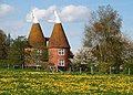
An orchard is an intentional plantation of trees or shrubs that is maintained for food production. Orchards comprise fruit- or nut-producing trees that are generally grown for commercial production. Orchards are also sometimes a feature of large gardens, where they serve an aesthetic as well as a productive purpose. A fruit garden is generally synonymous with an orchard, although it is set on a smaller, non-commercial scale and may emphasize berry shrubs in preference to fruit trees. Most temperate-zone orchards are laid out in a regular grid, with a grazed or mown grass or bare soil base that makes maintenance and fruit gathering easy. (Full article...)
-
The Cretaceous (IPA: /krɪˈteɪʃəs/ krih-TAY-shəs) is a geological period that lasted from about 145 to 66 million years ago (Mya). It is the third and final period of the Mesozoic Era, as well as the longest. At around 79 million years, it is the longest geological period of the entire Phanerozoic. The name is derived from the Latin creta, "chalk", which is abundant in the latter half of the period. It is usually abbreviated K, for its German translation Kreide. (Full article...)
-
The Darent is a Kentish tributary of the River Thames and takes the waters of the River Cray as a tributary in the tidal portion of the Darent near Crayford. 'Darenth' is frequently found as the spelling of the river's name in older books and maps, Bartholomew's Canals and River of England being one example. Bartholomew's Gazetteer (1954) demonstrates that Darent means "clear water", a result of it springing from and running through chalk. The purity of the water was a major factor in the development of paper and pharmaceuticals in the area. (Full article...)
-
Bexley is an area of south-eastern Greater London, England and part of the London Borough of Bexley. It is sometimes known as Bexley Village or Old Bexley to differentiate the area from the wider borough. It is located 13 miles (21 km) east-southeast of Charing Cross and south of Bexleyheath. (Full article...)
-
Swanley is a town and civil parish in the Sevenoaks District of Kent, England, 16 miles (26 km) southeast of central London, adjacent to the Greater London boundary and within the M25 motorway periphery. The population at the 2021 census was 17,826. (Full article...)
-
Plymouth (/ˈplɪməθ/ PLI-məth) is a port city and unitary authority in Devon, South West England. It is located on Devon's south coast between the rivers Plym and Tamar, about 36 miles (58 km) southwest of Exeter and 193 miles (311 km) southwest of London. It is the most populous city south of London. (Full article...)
-
Kent is a traditional county in South East England with long-established human occupation. (Full article...)
-
A music festival is a community event with performances of singing and instrument playing that is often presented with a theme such as musical genre (e.g., rock, blues, folk, jazz, classical music), nationality, locality of musicians, or holiday. Music festivals are generally organized by individuals or organizations within networks of music production, typically music scenes, the music industries, or institutions of music education. (Full article...)
-
Sir William Turner Walton OM (29 March 1902 – 8 March 1983) was an English composer. During a sixty-year career, he wrote music in several classical genres and styles, from film scores to opera. His best-known works include Façade, the cantata Belshazzar's Feast, the Viola Concerto, the First Symphony, and the British coronation marches Crown Imperial and Orb and Sceptre. (Full article...)
-
Royal Tunbridge Wells is a town in Kent, England, 30 miles (50 kilometres) southeast of central London. It lies close to the border with East Sussex on the northern edge of the High Weald, whose sandstone geology is exemplified by the rock formation High Rocks. The town was a spa in the Restoration and a fashionable resort in the mid-1700s under Beau Nash when the Pantiles, and its chalybeate spring, attracted visitors who wished to take the waters. Though its popularity as a spa town waned with the advent of sea bathing, the town still derives much of its income from tourism. (Full article...)
-
Augustine of Canterbury (early 6th century – most likely 26 May 604) was a Christian monk who became the first archbishop of Canterbury in the year 597. He is considered the "Apostle to the English”. (Full article...)
-
Old English (Englisċ, pronounced [ˈeŋɡliʃ]), or Anglo-Saxon, is the earliest recorded form of the English language, spoken in England and southern and eastern Scotland in the early Middle Ages. It developed from the languages brought to Great Britain by Anglo-Saxon settlers in the mid-5th century, and the first Old English literary works date from the mid-7th century. After the Norman Conquest of 1066, English was replaced for several centuries by Anglo-Norman (a type of French) as the language of the upper classes. This is regarded as marking the end of the Old English era, since during the subsequent period the English language was heavily influenced by Anglo-Norman, developing into what is now known as Middle English in England and Early Scots in Scotland. (Full article...)
