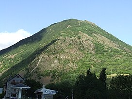
Roca de la Feixa
Appearance
| Roca de la Feixa | |
|---|---|
 Roca de la Feixa seen from Barruera | |
| Highest point | |
| Elevation | 2,093 m (6,867 ft) |
| Listing | Mountains in Catalonia |
| Coordinates | 42°30′12.79″N 0°50′19.47″E / 42.5035528°N 0.8387417°E |
| Geography | |
 | |
| Location | Alta Ribagorça, Catalonia |
| Parent range | Pyrenees |
| Climbing | |
| First ascent | Unknown |
| Easiest route | Drive to Durro, Vall de Boí, then hike |
Roca de la Feixa is a massive mountain of the Pyrenees, Catalonia, Spain. It has an elevation of 2,093 metres above sea level.[1]
This mountain's summit rises above Durro village. It is located within the municipal limits of Vall de Boí, Alta Ribagorça.
References
[edit]- ^ "Mapa Topogràfic de Catalunya". Institut Cartogràfic de Catalunya. Retrieved May 22, 2010..
