Sâg
Appearance
Sâg | |
|---|---|
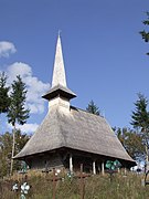
 Wooden church of Sârbi | |
 Location in Sălaj County | |
| Coordinates: 47°4′35″N 22°46′45″E / 47.07639°N 22.77917°E | |
| Country | Romania |
| County | Sălaj |
| Government | |
| • Mayor (2020–2024) | Florian Bonțe[1] (PSD) |
Area | 87.88 km2 (33.93 sq mi) |
| Elevation | 337 m (1,106 ft) |
| Population (2021-12-01)[2] | 3,324 |
| • Density | 38/km2 (98/sq mi) |
| Time zone | EET/EEST (UTC+2/+3) |
| Postal code | 457300 |
| Area code | +(40) 260 |
| Vehicle reg. | SJ |
| Website | www |
Sâg (Hungarian: Felsőszék) is a commune located in Sălaj County, Crișana, Romania. It is composed of five villages: Fizeș (Krasznafüzes), Mal (Ballaháza), Sâg, Sârbi (Krasznatótfalu), and Tusa (Tuszatelke).
Sights
[edit]- Wooden church in Sâg (built in the 18th century), historic monument[3]
- Wooden church in Tusa (built in the 18th century), historic monument[4]
References
[edit]- ^ "Results of the 2020 local elections". Central Electoral Bureau. Retrieved 14 June 2021.
- ^ "Populaţia rezidentă după grupa de vârstă, pe județe și municipii, orașe, comune, la 1 decembrie 2021" (XLS). National Institute of Statistics.
- ^ www.welcometoromania.ro - Wooden Church, Sârbi, retrieved on May 2, 2012
- ^ www.welcometoromania.ro - Wooden Church, Tusa, retrieved on May 2, 2012


