Sankt Paul im Lavanttal
Appearance
You can help expand this article with text translated from the corresponding article in German. (May 2012) Click [show] for important translation instructions.
|
Sankt Paul im Lavanttal | |
|---|---|
 | |
| Coordinates: 46°42′N 14°52′E / 46.700°N 14.867°E | |
| Country | Austria |
| State | Carinthia |
| District | Wolfsberg |
| Government | |
| • Mayor | Hermann Primus |
| Area | |
• Total | 47.34 km2 (18.28 sq mi) |
| Elevation | 412 m (1,352 ft) |
| Population (2018-01-01)[2] | |
• Total | 3,303 |
| • Density | 70/km2 (180/sq mi) |
| Time zone | UTC+1 (CET) |
| • Summer (DST) | UTC+2 (CEST) |
| Postal code | 9470 |
| Area code | 04357 |
| Website | [*http://www.sanktpaul.at] |
Sankt Paul im Lavanttal (Slovene: Sveti Pavel or Šentpavel) is a municipality of the Wolfsberg district in the Austrian state of Carinthia.
Geography
[edit]Sankt Paul lies in the Lavant River valley. A large part of the municipality lies in the Granitz River valley and in the foothills of the Saualp.
History
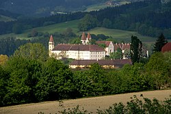
[edit]The village has always been under the influence of the monastery, which is still a significant economic factor today.
It was only in 1874 that the telegraph came to St. Paul. The opening of a k.k. State telegraph station with "limited daily services" took place at the same time as in other smaller places of the monarchy.[3]
Sights
[edit]See also
[edit]References
[edit]- ^ "Dauersiedlungsraum der Gemeinden Politischen Bezirke und Bundesländer - Gebietsstand 1.1.2018". Statistics Austria. Retrieved 10 March 2019.
- ^ "Einwohnerzahl 1.1.2018 nach Gemeinden mit Status, Gebietsstand 1.1.2018". Statistics Austria. Retrieved 9 March 2019.
- ^ "Kundmachungen". Klagenfurter Zeitung (in German). Klagenfurt: ANNO. 1874-12-10. p. 6. Retrieved 2019-09-07.
External links
[edit]

Wikimedia Commons has media related to Sankt Paul im Lavanttal.


