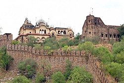
Sendhwa
This article possibly contains original research. (July 2016) |
Sendhwa
Sendhawa | |
|---|---|
 Sendhwa Fort | |
| Coordinates: 21°41′05″N 75°05′43″E / 21.68472°N 75.09528°E | |
| Country | |
| State | Madhya Pradesh |
| District | Barwani |
| Area | |
• Total | 18 km2 (7 sq mi) |
| Elevation | 409 m (1,342 ft) |
| Population (2011)[1] | |
• Total | 56,485 |
| • Density | 3,100/km2 (8,100/sq mi) |
| Languages | |
| • Official | Hindi |
| Time zone | UTC+5:30 (IST) |
| PIN | 451666 |
| Telephone code | 07281 |
| Vehicle registration | MP 46 |
| Sex ratio | 926 per 1000 males ♂/♀ |
Sendhwa is a city with a municipal government in Barwani district in the Indian state of Madhya Pradesh. It is the headquarters for Sendhwa Tehsil.[1]
Geography
[edit]Sendhwa is located at MH&MP Border 21°41′N 75°06′E / 21.68°N 75.1°E.[2] It has an average elevation of 409 metres (1341 feet).
Demographics
[edit][needs update] As of the 2011 Census of India,[3] Sendhwa had a population of 56,485. Males constitute 52% of the population and females 48%. Sendhwa has an average literacy rate of 63%, higher than the national average of 59.5%: male literacy is 70%, and female literacy is 55%. In Sendhwa, 17% of the population is under 6 years of age.
Economy
[edit]Sendhwa is a famous cotton market, this area is adjacent to the cotton belt of Maharashtra, many cotton ginning factories are located in Sendhwa, along with this a wide market of cotton is available here.
Sendhwa is primarily agricultural and forest lands. Mechanised farming has only been recently introduced.[4] Cotton is a big crop,[5] as are pulses, such as mung beans and moth beans.[6] Other crops include wheat, sorghum (jowar), maize, millet (kodo-kutki), especially pearl millet (bajra), rapeseed (canola), mustard, and urd and other pulses (gram).
Government
[edit]Sendhawa Assembly constituency is one of the 230 Vidhan Sabha (Legislative Assembly) constituencies of Madhya Pradesh state in central India.[7] Gyarsilal Rawat is mla from Sendhwa. Sendhwa assembly is part of Khargone lok sabha.
Administration
[edit]Sendhwa is a Municipality city in district of Barwani, Madhya Pradesh. The Sendhwa city is divided into 24 wards for which elections are held every 5 years.[8]
Sendhwa Municipality has total administration over 10,108 houses to which it supplies basic amenities like water and sewerage. It is also authorize to build roads within Municipality limits and impose taxes on properties coming under its jurisdiction.[9]
Education
[edit]For higher education some Colleges and institute are available in Sendhwa -
- Govt PG College, Sendhwa [10]
- Homeopathic Medical College Sendhwa[11]
- Ma Renuka institute of Management Sendhwa[12]
- Swami Vivekananda College Sendhwa[13]
Tourist Place
[edit]- Sendhwa Fort, It's a historical and Beautiful fort situated in Sendhwa
- Bijasan Mata Mandir, Bijasan mata Mandir is located on border of Madhya Pradesh and Maharashtra, it's a religious place.[14]
Transportation
[edit]Sendhwa is 60 km away from Barwani and 160 km away from Divisional Headquarter Indore. Sendhwa is well connected with roads. Agra Bombay Highway passing through Sendhwa.
Sendhwa is connected by private bus services to all nearest major cities.
References
[edit]- ^ a b Sinha, Sachin et al., Directorate of Census Operations, Madhya Pradesh (2015). District Census Handbook, Barwani, Census of India 2011: Village and Town Wise Primay Census Abstract (PDF). Series-24, PART XII-B. p. 14. Archived (PDF) from the original on 30 August 2015.
{{cite book}}: CS1 maint: multiple names: authors list (link) - ^ Falling Rain Genomics, Inc - Sendhwa
- ^ "Census of India 2001: Data from the 2001 Census, including cities, villages and towns (Provisional)". Census Commission of India. Archived from the original on 16 June 2004. Retrieved 1 November 2008.
- ^ Pawar, Aarti & Kusumakar, Aruna (2013). "कृषि मे यंत्रीकरण का ग्रामीण अर्थव्यवस्था पर प्रभाव का अध्ययन (सेंधवा तहसील के विशेष संदर्भ मे )" [A Study of the Impact of the Mechanization of Agriculture in a Rural Economy (in reference to Sendhawa Tehsil)] (PDF). Review of Research Journal (in Hindi). 3 (2). Archived (PDF) from the original on 30 August 2015.
- ^ Superintendent of Census Operations; Madhya Pradesh (1964). District Census Handbook, Madhya Pradesh, Census of India 1961. Volume 41 of District Census Handbook. Indore, India: Government of Madhya Pradesh. p. lxix.
- ^ Jain, C. K. (1988). Patterns of Agricultural Development in Madhya Pradesh. New Delhi: Northern Book Centre. p. 116. ISBN 978-81-85119-41-0.
- ^ "Madhya Pradesh 2013". myneta.info. National Election Watch. Retrieved 18 May 2018.
- ^ https://www.nagarpalikasendhwa.org/
- ^ "Nagar Palika Sendhwa | District Barwani, Government of Madhya Pradesh | India".
- ^ "Govt P G College Sendhwa | District Barwani, Government of Madhya Pradesh | India".
- ^ https://www.shmcsendhwa.com/
- ^ "INSTITUTE MANAGEMENT SYSTEM: MAA RENUKA INSTITUTE OF MANAGEMENT, SENDHWA BADWANI | National Government Services Portal".
- ^ https://www.svsms.org/
- ^ "आप भी करें मां के इस चमत्कारी मंदिर के दर्शन, जहां जाते ही मिलता ये खास संकेत - mobile". 8 July 2022.

