
Si Thep Historical Park
อุทยานประวัติศาสตร์ศรีเทพ | |
 Khao Khlang Nok, one of the largest known ancient Dvaravati structures, 7th–8th century CE | |
 | |
| Location | Phetchabun province, Thailand |
|---|---|
| Type | Human settlement |
| Area | 4.7 square kilometres (470 ha) |
| History | |
| Founded | 4th century |
| Abandoned | 14th century |
| Periods | Ancient history |
| Cultures | Dvaravati |
| Associated with | Mon people |
| Site notes | |
| Discovered | 1904 |
| Excavation dates | 1935 |
| Archaeologists | Damrong Rajanubhab |
| Condition | Partial restoration |
| Ownership | Public |
| Management | Fine Arts Department, entry fee |
| Public access | Yes |
| Architecture | |
| Architectural styles | |
| Official name | The Ancient Town of Si Thep and Its Associated Dvaravati Monuments |
| Type | Cultural |
| Criteria | ii, iii |
| Designated | 2023 (45th session) |
| Reference no. | 1662 |
| Area | 866.471 ha |
| Region | Asia and the Pacific |
Si Thep Historical Park (Thai: อุทยานประวัติศาสตร์ศรีเทพ) is an archaeological site in Thailand's Phetchabun province. It covers the ancient city of Si Thep, a site inhabited from around the third to fifth century CE until the thirteenth century, spanning cultural periods from late prehistory, through Dvaravati, to the golden age of the Khmer Empire. Si Thep was one of the largest known city-states that emerged around the plains of central Thailand in the first millennium, but became abandoned around the time the Thai-speaking cities of Sukhothai and later Ayutthaya emerged as new centres of power in the Chao Phraya River basin.[1]
The site gained the attention of modern archaeology in 1904 following surveys by Prince Damrong Rajanubhab, and it was listed as an ancient monument in 1935. The Fine Arts Department has undertaken continued study and excavations of the site, which has also been studied by archaeologists Prince Subhadradis Diskul, H. G. Quaritch Wales and Jean Boisselier, among others.[1]
As per historical evidence found on the site, Si Thep was possibly the center of the Dvaravati mandalas.[2][3] Via royal intermarriage, it was also considered the sister city of Sema, the capital of the neighboring state, Canasapura, located eastward on the opposite side of the Dong Phaya Yen Mountains in the Mun River basin.[3]
Si Thep was listed as a historical park in 1984 and was proposed as a tentative UNESCO World Heritage Site by Thailand in 2019.[4] On 19 September 2023, it was inscribed on the World Heritage List as The Ancient Town of Si Thep and Its Associated Dvaravati Monuments. It is Thailand's first successful cultural World Heritage Site nomination since Ban Chiang in 1992.[5][6]
History[edit]
Early settlement: 4th–5th century CE[edit]
Si Thep was developed from a prehistoric farming village in the Pa Sak valley approximately 2,500–1,500 years ago.[7] In the first archaeological phase (c. 4th–5th century CE), the early settlement of Si Thep occupied the inner town and there was a burial tradition with offerings related to India and communities to the central region and Moon River basin to the northeast.[8]
Hindu-influenced era: 6th–8th century CE[edit]
The second phase of occupation (c. 6th–8th century CE) was characterized by the expansion to the outer city. As the monarchy emerged, Vaishnavism took an important role in Si Thep's society, with relationships to India, Funan, Chenla, and Dvaravati cultures.[8] Si Thep was an urban Dvaravati culture center since the 6th century CE, and one of the earliest communities in Thailand that made contacts with India, attested in stone inscription K 978, written in Sanskrit with Pallava script dated to the 6th century CE. So, Si Thep was developed into an early state along with other early Southeast Asian states like Funan, Chenla, and Sri Ksetra.[9] Charles Higham reports of a 7th-century Dvaravati inscription from Si Thep that states, "In the year...a king who is nephew of the great King, who is the son of Pruthiveenadravarman, and who is great as Bhavavarman, who has renowned moral principles, who is powerful and the terror of his enemies, erects this inscription on ascending the throne." A moat enclosed 4.7 square km, while the Khao Klang Nai structure (Thai: เขาคลังใน) dates from the 6th to 7th century.[10]: 303, 308–309
Buddhism-influenced era: 8th–10th century CE[edit]
This phase (c. 8th–10th century CE) was the most prosperous. An irrigation system was developed, and Mahayana Buddhism influenced art as relationships with India, Dvaravati and northeastern cities continued. Si Thep, Sema, and Lopburi sites controlled the routes in the region.[8] The growth of Si Thep led to the establishment of its neighboring city, Tha Rong (Thai: ท่าโรง), located 20 kilometers northward on the bank of the Pasak River, which was later renamed Wichian Buri during the reign of King Nangklao of Rattanakosin.[11] Via Buddhism, several historical evidences supports the connection between Si Thep and another group of Dvaravati-influenced political entities in present Northeast Thailand, Wen Dan.[12]: 91–92
During this era, Si Thep, together with Lavo, was the center of the mandala-style state, Dvaravati; however, due to the weather-induced migration or the pandemic, Si Thep lost its prosperity, and Lavo became the only center of power in the area until it fell under Khmer hegemony during the 10th to 11th centuries.[13]
Rise of Angkorian: 11th–13th century CE[edit]
During this phase (c. 11th–13th century CE), Shaivism was a great influence in Si Thep at Angkorian times, and Si Thep had relationships with Phimai in Mun River basin as Sema ceased to control the routes. Due to Jayavarman VII's policy, Si Thep lost importance and was almost abandoned around the 14th century.[8] Prang Song Phi Nong and Prang Si Thep were built in the 11th to 12th centuries.[10]: 303, 308–309
After the decline of Si Thep in the 14th century, a new kingdom, Ayutthaya, was subsequently founded southward on the bank of the Chao Phraya River in mid-14th CE, as the succeeded state,[2] as its capital's full name referred to the mandalas of Dvaravati; Krung Thep Dvaravati Si Ayutthaya (Thai: กรุงเทพทวารวดีศรีอยุธยา).[14][15][16][17] The connection between the ancient Mon people, the predominant population of the Dvaravati, and the present-day Thai people in central Thailand, who are the inheritors of Siamese's Ayutthaya, was established in several genetic studies performed in the 20th century.[18]
Extant structures[edit]
Within the inner city[edit]
- Khao Khlang Nai (Thai: เขาคลังใน)
- Prang Si Thep (Thai: ปรางค์ศรีเทพ)
- Prang Song Phi Nong (Thai: ปรางค์สองพี่น้อง)
Outside the inner city[edit]
- Khao Khlang Nok (Thai: เขาคลังนอก)
- Prang Ruesi (Thai: ปรางค์ฤๅษี)
Gallery[edit]
-
 Map of Si Thep Historical Park
 -
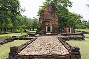
 Khao Khlang Nai was a Buddhist sanctuary. The central stupa, rectangular in shape and oriented toward the east, is characteristic of the Dvaravati architectural style, dated back around 6th–7th century CE.
 -
 Prang Si Thep, built in Khmer architectural style in the late Dvaravati period around the 12th century.
 -
 Prang Song Phi Nong
 -
 Prang Ruesi


References[edit]
- ^ a b "อุทยานประวัติศาสตร์ศรีเทพ: ประวัติที่มาและความสำคัญ". virtualhistoricalpark.finearts.go.th (in Thai). Fine Arts Department. Retrieved 21 September 2023.
- ^ a b "หลักฐานฟ้อง! ทำไมจึงเชื่อได้ว่า "ศรีเทพ" คือศูนย์กลางทวารวดี". www.silpa-mag.com (in Thai). 13 December 2023. Archived from the original on 14 December 2023. Retrieved 14 December 2023.
- ^ a b ""ศรีเทพ-เสมา" เมืองเครือข่าย ศรีทวารวดี-ศรีจนาศะ?". www.silpa-mag.com (in Thai). 24 November 2023. Archived from the original on 14 December 2023. Retrieved 14 December 2023.
- ^ Karnjanatawe, Karnjana (28 January 2021). "Unesco to get Si Thep report". Bangkok Post. Retrieved 18 August 2022.
- ^ "Si Thep historical park recognised as UNESCO World Cultural Heritage Site". www.thaipbsworld.com.
- ^ "As Thai town joins Unesco list, site 'completely unprepared' for tourism". South China Morning Post. 20 September 2023.
- ^ World Heritage Convention, (2019). "The Ancient Town of Si Thep", Tentative Lists, UNESCO.
- ^ a b c d Depimai, Anurak (2020). The Cultural Development of Si-Thep as the Hinterland Ancient Town Prior to 14th Century (Ph.D. thesis). Silpakorn University.
- ^ World Heritage Convention, (2019). "The Ancient Town of Si Thep", Tentative Lists, UNESCO.
- ^ a b Higham, Charles (2014). Early Mainland Southeast Asia: From First Humans to Angkor. Bangkok: River Books. ISBN 9786167339443.
- ^ "จาก "ศรีเทพ" สู่ "วิเชียรบุรี" ประวัติศาสตร์พันปีที่เชื่อมโยงถึงกัน". www.silpa-mag.com (in Thai). 19 December 2023. Archived from the original on 19 December 2023. Retrieved 19 December 2023.
- ^ Hiram Woodward (2023). "Dvaravati, Si Thep, and Wendan". Archived from the original on 15 October 2022.
- ^ อธิษฐาน จันทร์กลม (6 September 2019). "หลงกลิ่นอาย 'ละโว้ ศรีเทพ เสมา' มัณฑละแห่ง 'ศรีจนาศะ'". Matichon (in Thai). Archived from the original on 26 October 2023. Retrieved 26 October 2023.
- ^ Boeles, J.J. (1964). "The King of Sri Dvaravati and His Regalia" (PDF). Journal of the Siam Society. 52 (1): 102–103. Retrieved 13 April 2023.
- ^ Pongsripian, Winai (1983). Traditional Thai historiography and its nineteenth century decline (PDF) (PhD). University of Bristol. p. 21. Retrieved 13 April 2023.
- ^ Blagden, C.O. (1941). "A XVIIth Century Malay Cannon in London". Journal of the Malayan Branch of the Royal Asiatic Society. 19 (1): 122–124. JSTOR 41559979. Retrieved 13 April 2023.
TA-HTAUNG TA_YA HNIT-HSE SHIT-KHU DWARAWATI THEIN YA - 1128 year (= 1766 A.D) obtained at the conquest of Dwarawati (= Siam). One may note that in that year the Burmese invaded Siam and captured Ayutthaya, the capital, in 1767.
- ^ JARUDHIRANART, Jaroonsak (2017). THE INTERPRETATION OF SI SATCHANALAI (Thesis). Silpakorn University. p. 31. Retrieved 13 April 2023.
Ayutthaya, they still named the kingdom after its former kingdom as "Krung Thep Dvaravati Sri Ayutthaya".
- ^ Kutanan, Wibhu; Liu, Dang; Kampuansai, Jatupol; Srikummool, Metawee; Srithawong, Suparat; Shoocongdej, Rasmi; Sangkhano, Sukrit; Ruangchai, Sukhum; Pittayaporn, Pittayawat; Arias, Leonardo; Stoneking, Mark (2021). "Reconstructing the Human Genetic History of Mainland Southeast Asia: Insights from Genome-Wide Data from Thailand and Laos". Mol Biol Evol. 38 (8): 3459–3477. doi:10.1093/molbev/msab124. PMC 8321548. PMID 33905512.
External links[edit]
- Si Thep Historical Park at the Fine Arts Department's Virtual Historical Park website
- The Ancient Town of Si Thep – official Tentative List submission
15°27′58″N 101°09′02″E / 15.46611°N 101.15056°E
| Cultural |  | |
|---|---|---|
| Natural | ||
Dvaravati Historical Sites | |
|---|---|
| |
| Central Thailand | |
| Northeastern Thailand | |
| Western Thailand | |