Sompolno
Sompolno | |
|---|---|
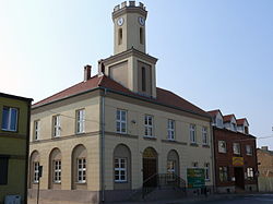
 Town Hall | |
| Coordinates: 52°24′40″N 18°30′10″E / 52.41111°N 18.50278°E | |
| Country | |
| Voivodeship | Greater Poland |
| County | Konin |
| Gmina | Sompolno |
| Area | |
• Total | 6.21 km2 (2.40 sq mi) |
| Population (2016) | |
• Total | 3,614 |
| • Density | 580/km2 (1,500/sq mi) |
| Time zone | UTC+1 (CET) |
| • Summer (DST) | UTC+2 (CEST) |
| Postal code | 62-610 |
| Vehicle registration | PKN |
| Voivodeship roads | |
| Website | http://www.sompolno.pl |
Sompolno [sɔmˈpɔlnɔ] is a town in Konin County, Greater Poland Voivodeship, in central Poland, with 3,614 inhabitants (2016).
History
[edit]In the 10th century, the area became part of the emerging Polish state under its first historic ruler Mieszko I. In 1242, Duke Casimir I of Kuyavia from the Piast dynasty stayed in Sompolno, and issued a privilege for the Sulejów Abbey there.[1] Sompolno was granted town rights in 1477. It was a royal town, administratively located in the Brześć Kujawski Voivodeship in the Greater Poland Province of the Kingdom of Poland. A route connecting Warsaw with Poznań and Dresden ran through the town in the 18th century and King Augustus III of Poland often traveled that route.[2]
During the German occupation of Poland (World War II), Sompolno was renamed to Deutscheck between 1939–1943 and then later to Deutscheneck between 1943–1945[3] in attempt to erase traces of Polish origin.
Sports
[edit]The local football club is GKS Sompolno. It competes in the lower leagues.
Gallery
[edit]-
Church of St. Mary Magdalene
-
Saint Jerome chapel, 17th century
-
Heritage tree Sorbus torminalis
-
Heritage tree
References
[edit]- ^ Słownik geograficzny Królestwa Polskiego i innych krajów słowiańskich, Tom XV Część II (in Polish). Warszawa. 1902. p. 611.
{{cite book}}: CS1 maint: location missing publisher (link) - ^ "Informacja historyczna". Dresden-Warszawa (in Polish). Retrieved 27 November 2023.
- ^ Vgl. Weblink „Anordnung über Ortsnamenänderung im Reichsgau Wartheland“ - Landkreis Konin


