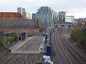
St Paul's tram stop
| West Midlands Metro tram stop | |
 View of stop, Looking towards Snow Hill station, with the railway lines alongside. | |
| General information | |
| Location | St Paul's Square, Birmingham England |
| Line(s) | Line 1 (Edgbaston Village – Wolverhampton St George's/Wolverhampton Station) |
| Platforms | 2 |
| History | |
| Opened | 31 May 1999 |
| Passengers | |
| 2015/16 | Approx. 800 daily[1] |
St Paul's tram stop is a tram stop serving nearby St Paul's Square, Birmingham, England. It was opened on 31 May 1999 on West Midlands Metro Line 1. The stop is a short distance west of Birmingham Snow Hill station, which is visible from the stop. Pedestrian access is via Constitution Hill.
The stop sits in the shadow of Livery Street, which, at this point, is on a blue-brick lined embankment, preventing direct access to the square. Livery Street then crosses the tram and railway lines, at a very acute angle, at the Wolverhampton end of the stop.
The Birmingham to Worcester railway line runs alongside, but the stop is served only by trams, as there are no railway platforms.
Services
[edit]On Mondays to Fridays, West Midlands Metro services in each direction between Edgbaston Village and Wolverhampton St George's/Wolverhampton Station run at six to eight-minute intervals during the day, and at fifteen-minute intervals during the evenings and on Sundays. They run at eight minute intervals on Saturdays.[2]
References
[edit]- ^ "2016 West Midlands Travel Trends Covering Report" (PDF). West Midlands Combined Authority. p. 39. Archived from the original (PDF) on 2 February 2017. Retrieved 23 January 2017.
- ^ "Midland Metro timetable". Network West Midlands. Retrieved 11 July 2019.

