Sudoeste/Octogonal
Appearance
Sudoeste/Octogonal | |
|---|---|
| Região Administrativa de Sudoeste/Octogonal Administrative Region of Sudoeste/Octogonal | |
Clockwise from top: Setor de Indústrias Gráficas; Hospital das Forças Armadas | |
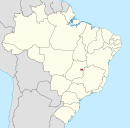
 Location of Sudoeste/Octogonal in the Federal District | |
| Coordinates: 15°48′01″S 47°55′27″W / 15.80028°S 47.92417°W | |
| Country | |
| Region | Central-West |
| State | |
| Founded | 10 July 1989 |
| Time zone | UTC-3 (UTC-3) |
| • Summer (DST) | UTC-2 (UTC-2) |
| Website | www |
Sudoeste/Octogonal is an administrative region in the Federal District in Brazil.[1][2] It is largely surrounded by Brasília to the east, and bordered by SIA and Cruzeiro to the west. Sudoeste/Octogonal was founded on July 10, 1989, receiving the status of administrative region, according to Law 3153, of May 6, 2003.
References
[edit]- ^ "Dicionário-Base-Domicílios-PDAD-1.xlsx". CODEPLAN. Retrieved 27 January 2019.
- ^ "Regional Administrations". Governo do Distrito Federal. Retrieved 27 January 2019.
External links
[edit]Wikimedia Commons has media related to Sudoeste/Octogonal.


