Susumansky District
Susumansky District
Сусуманский район | |
|---|---|
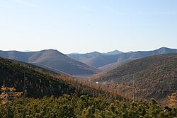
 Burkhalinsky Pass as seen from the Susuman side | |
 Location of Susumansky District in Magadan Oblast | |
| Coordinates: 62°47′N 148°09′E / 62.783°N 148.150°E | |
| Country | Russia |
| Federal subject | Magadan Oblast[1] |
| Established | December 2, 1953[2] |
| Administrative center | Susuman[1] |
| Area | |
• Total | 46,800 km2 (18,100 sq mi) |
| Population | |
• Total | 9,015 |
• Estimate (January 2017)[4] | 1,471 |
| • Density | 0.19/km2 (0.50/sq mi) |
| • Urban | 97.1% |
| • Rural | 2.9% |
| Administrative structure | |
| • Inhabited localities[1] | 1 cities/towns, 6 Urban-type settlements[5], 6 rural localities |
| Municipal structure | |
| • Municipally incorporated as | Susumansky Urban Okrug[6] |
| Time zone | UTC+11 (MSK+8 |
| OKTMO ID | 44713000 |
| Website | http://susumanskiy-rayon.ru |
Susumansky District (Russian: Сусума́нский райо́н) is an administrative district (raion), one of the eight in Magadan Oblast, Russia.[1] As a municipal division, it is incorporated as Susumansky Urban Okrug.[6] It is located in the southeast of the oblast and borders the Sakha Republic in the west and north, Srednekansky District in the east, and Yagodninsky and Tenkinsky Districts in the south.[2] The area of the district is 46,800 square kilometers (18,100 sq mi).[2] Its administrative center is the town of Susuman.[1] As of the 2010 Census, the total population of the district was 9,015, with the population of Susuman accounting for 65.0% of that number.[3]
| Year | Pop. | ±% |
|---|---|---|
| 1959 | 35,365 | — |
| 1970 | 41,573 | +17.6% |
| 1979 | 47,787 | +14.9% |
| 1989 | 47,950 | +0.3% |
| 2002 | 14,022 | −70.8% |
| 2010 | 9,015 | −35.7% |
| 2021 | 6,458 | −28.4% |
| Source: Census data | ||
Geography
[edit]The landscape of the district is mostly mountainous. The Nera Plateau and the Tas-Kystabyt are located in the northwestern part of the district.[8]
History
[edit]The district was established on December 2, 1953.[2]
Administrative and municipal status
[edit]Within the framework of administrative divisions, Susumansky District is one of the eight in the oblast.[1] The town of Susuman serves as its administrative center.[1]
As a municipal division, the district has been incorporated as Susumansky Urban Okrug since May 1, 2015.[6] Prior to that date, the district was incorporated as Susumansky Municipal District, which was subdivided into three urban settlements and one rural settlement.
Economy
[edit]The main industries in the district are gold and coal mining. Despite being rich in natural resources, the district economy suffered in the first decades of the 2000s. The severe climate and poorly developed infrastructure are partly to blame, but the difficult transition from Soviet times has led to the collapse of a number of companies with the result that many inhabitants have left the region.[9]
Notable residents
[edit]- Oleksandr Romanovskyi (born 1952 in Neksykan village), Ukrainian politician
- Efim Shifrin (born 1956 in Neksykan village), actor and singer
References
[edit]Notes
[edit]- ^ a b c d e f g Law #1292-OZ
- ^ a b c d e "About the Municipal Formation" (in Russian). Susumansky Urban Okrug. Retrieved February 1, 2018.
- ^ a b Russian Federal State Statistics Service (2011). Всероссийская перепись населения 2010 года. Том 1 [2010 All-Russian Population Census, vol. 1]. Всероссийская перепись населения 2010 года [2010 All-Russia Population Census] (in Russian). Federal State Statistics Service.
- ^ Office of the Federal State Statistics Service for Khabarovsk Krai, Magadan Oblast, Jewish Autonomous Oblast, and Chukotka Autonomous Okrug. Численность населения Магаданской области по муниципальным образованиям на 1 января 2017 года (Magadan Oblast Municipal Formations Population as of January 1, 2017) (in Russian)
- ^ The count of urban-type settlements may include the work settlements, the resort settlements, the suburban (dacha) settlements, as well as urban-type settlements proper.
- ^ a b c Law #1886-OZ
- ^ "Об исчислении времени". Официальный интернет-портал правовой информации (in Russian). June 3, 2011. Retrieved January 19, 2019.
- ^ Google Earth
- ^ K. Mueller and M.J. Bradshaw. Simulating Population Change in the Russian Far East. European Journal of Population, 22:105–126. OPTIMIRUS.
Sources
[edit]- Магаданская областная Дума. Закон №1292-ОЗ от 9 июня 2010 г. «Об административно-территориальном устройстве Магаданской области», в ред. Закона №1756-ОЗ от 9 июня 2014 г. «О внесении изменений в Закон Магаданской области "Об административно-территориальном устройстве Магаданской области"». Вступил в силу через 10 дней после дня официального опубликования. Опубликован: Приложение к газете "Магаданская правда", №63(20183), 16 июня 2010 г. (Magadan Oblast Duma. Law #1292-OZ of June 9, 2010 On the Administrative-Territorial Structure of Magadan Oblast, as amended by the Law #1756-OZ of June 9, 2014 On Amending the Law of Magadan Oblast "On the Administrative-Territorial Structure of Magadan Oblast". Effective as of the day which is 10 days after the official publication date.).
- Магаданская областная Дума. Закон №1886-ОЗ от 8 апреля 2015 г. «О преобразовании муниципальных образований "город Сусуман", "посёлок Широкий", "посёлок Холодный", "посёлок Мяунджа" путём их объединения с наделением статуса городского округа», в ред. Закона №1967-ОЗ от 9 декабря 2015 г «О внесении изменений в отдельные Законы Магаданской области и признании утратившими силу отдельных Законов Магаданской области». Вступил в силу 1 мая 2015 г. Опубликован: Приложение к газете "Магаданская правда", №29 (20785), 14 апреля 2015 г. (Magadan Oblast Duma. Law #1886-OZ of April 8, 2015 On the Transformation of the Municipal Formations of the "Town of Susuman", "Settlement of Shiroky", "Settlement of Kholodny", "Settlement of Myaundzha" by Merging Them and Giving Them a Status of the Urban Okrug, as amended by the Law #1967-OZ of December 9, 2015 On Amending Various Laws of Magadan Oblast and Abrogating Various Laws of Magadan Oblast. Effective as of May 1, 2015.).


