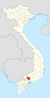
Tân Phước Khánh
Appearance
You can help expand this article with text translated from the corresponding article in Vietnamese. (February 2024) Click [show] for important translation instructions.
|
Tân Phước Khánh | |
|---|---|
 | |
| Country | |
| Province | Bình Dương |
| Town | Tân Uyên |
| Founded |
|
| Area | |
• Total | 3.93 sq mi (10.18 km2) |
| Population (2021) | |
• Total | 62,778[3] |
| • Density | 15,970/sq mi (6,167/km2) |
| Time zone | UTC+07:00 (Indochina Time) |
Tân Phước Khánh is a ward (phường) of Tân Uyên town in Bình Dương Province, Vietnam.[4]
References
[edit]- ^ Cite error: The named reference
54-CPwas invoked but never defined (see the help page). - ^ Cite error: The named reference
136/NQ-CPwas invoked but never defined (see the help page). - ^ Công văn số 157/TB-SYT: Đánh giá cấp độ dịch Covid-19 trên địa bàn tỉnh Bình Dương (tính đến 18g00’ ngày 03 tháng 11 năm 2021). "Dân số đến 03 tháng 11 năm 2021 - tỉnh Bình Dương" (PDF).
{{cite web}}: CS1 maint: numeric names: authors list (link) - ^ "Administrative subdivisions". General Statistics Office of Vietnam. To find information at reference, go to row 74, then row 723, and it is listed on row 25891.
11°00′N 106°43′E / 11.000°N 106.717°E

