Taali (village)
Appearance
Taali | |
|---|---|
Village | |
 Taali manor | |
 | |
| Country | |
| County | Pärnu County |
| Parish | Tori Parish |
| Time zone | UTC+2 (EET) |
| • Summer (DST) | UTC+3 (EEST) |
Taali is a village in Tori Parish, Pärnu County in southwestern Estonia.[1]
Taali manor
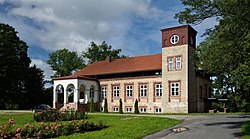
[edit]Taali manor derives its name (German: Staelenhof) from the family Staël von Holstein, who received the estate as a gift in the 17th century and who were the owners until the Estonian land reform of 1919. The present-day limestone building, in neo-Renaissance style, was built in 1852 but heavily damaged during World War II. Today only about one third of the original building remains.[2][3]
References
[edit]- ^ Classification of Estonian administrative units and settlements 2014[dead link] (retrieved 28 July 2021)
- ^ Sakk, Ivar (2004). Estonian Manors - A Travelogue. Tallinn: Sakk & Sakk OÜ. p. 298. ISBN 9949-10-117-4.
- ^ Hein, Ants (2009). Eesti Mõisad - Herrenhäuser in Estland - Estonian Manor Houses. Tallinn: Tänapäev. p. 166. ISBN 978-9985-62-765-5.
58°27′N 24°47′E / 58.450°N 24.783°E

