Jump to content

英文维基 | 中文维基 | 日文维基 | 草榴社区

Template:Infobox lighthouse/testcases

From Wikipedia, the free encyclopedia

Baker Island Light

[edit]
Side by side comparison
{{Infobox lighthouse}}{{Infobox lighthouse/sandbox}}
Baker Island Light
Map
LocationBaker Island, Hancock County, Cranberry Isles, US
Coordinates44°14′28″N 68°11′56″W / 44.241209°N 68.199012°W / 44.241209; -68.199012
Tower
Constructed1828 Edit this on Wikidata
Constructionbrick (tower) Edit this on Wikidata
Automated1966 Edit this on Wikidata
Height13 m (43 ft) Edit this on Wikidata
Shapetruncated cone Edit this on Wikidata
Markingswhite (tower) Edit this on Wikidata
HeritageNational Register of Historic Places listed place Edit this on Wikidata
Light
First lit1855 Edit this on Wikidata
Focal height32 m (105 ft) Edit this on Wikidata
Range10 nmi (19 km; 12 mi) Edit this on Wikidata
CharacteristicFl W 10s Edit this on Wikidata

Lighthouse of Alexandria

[edit]
Side by side comparison
{{Infobox lighthouse}}{{Infobox lighthouse/sandbox}}
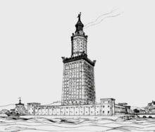
Lighthouse of Alexandria
Drawing by archaeologist Hermann Thiersch (1909)
Map
LocationPharos, Alexandria, Egypt
Coordinates31°12′50″N 29°53′08″E / 31.21389°N 29.88556°E / 31.21389; 29.88556
Tower
Constructedbetween 284 and 246 BC
FoundationStone
ConstructionMasonry
Height120–137 m (394–449 ft)[citation needed]
Shapesquare (bottom), octagon (central part), circle (top) Edit this on Wikidata
Light
Deactivated1303/1323
Range47 km (29 mi)

Longships Lighthouse

[edit]
Side by side comparison
{{Infobox lighthouse}}{{Infobox lighthouse/sandbox}}
Longships Lighthouse
Longships lighthouse from the seaward side
Map
LocationLongships, Land's End
Cornwall
England
Coordinates50°4′00.69″N 5°44′48.39″W / 50.0668583°N 5.7467750°W / 50.0668583; -5.7467750
Tower
Constructed1795 (first)
Constructiongranite tower
Automated1988
Height35 m (115 ft)
Shapetapered cylindrical tower with lantern and helipad on the top
Markingsunpainted tower, white lantern
OperatorTrinity House[1]
Fog signalone second blast every 10 seconds
Light
First lit1875 (current)
Focal height35 m (115 ft)
Lensfirst order dioptric lens Edit this on Wikidata
Intensity14,400 candela Edit this on Wikidata
Range15 nmi (28 km; 17 mi)
CharacteristicIso WR 10s.

Whitby West Pier

[edit]
Side by side comparison
{{Infobox lighthouse}}{{Infobox lighthouse/sandbox}}
Whitby West Pier Lighthouse
Lighthouses on the East and West Piers, and beacons on the pier extensions
Map
LocationWhitby
North Yorkshire
England
OS gridNZ893109
Coordinates54°29′34″N 0°36′46″W / 54.492814°N 0.612889°W / 54.492814; -0.612889
Tower
Constructed1831 (first)
Constructionwooden tower (current)
stone tower (first)
Height7 metres (23 ft) (current)
25 metres (82 ft) (first)
Shapecylindrical lantern on a four legs skeletal structure (current)
cylindrical tower with balcony and lantern (first)
Markingsred lantern, unpainted structure (current)
unpainted tower, white lantern, black lantern dome (first)
OperatorWhitby Harbour[2]
HeritageGrade II listed
Fog signal1 blast every 30s
Light
First lit1914 (current)
Focal height14 metres (46 ft) (current)
Range5 nmi (9.3 km; 5.8 mi)
CharacteristicF G (current)
occasionally F G (first)

Ardnamurchan

[edit]
Side by side comparison
{{Infobox lighthouse}}{{Infobox lighthouse/sandbox}}
Ardnamurchan Lighthouse
Map
LocationArdnamurchan Point, Ardnamurchan, Highland, United Kingdom Edit this at Wikidata
OS gridNM4158767473
Coordinates56°43′38″N 6°13′34″W / 56.7271°N 6.22602°W / 56.7271; -6.22602
Tower
Constructed1849 Edit this on Wikidata
Built byAlan Stevenson Edit this on Wikidata
Constructiongranite (tower) Edit this on Wikidata
Automated1988 Edit this on Wikidata
Height35 m (115 ft) Edit this on Wikidata
OperatorNorthern Lighthouse Board Edit this on Wikidata
Heritagecategory A listed building Edit this on Wikidata
Light
Focal height55 m (180 ft) Edit this on Wikidata
Range24 nmi (44 km; 28 mi) Edit this on Wikidata
CharacteristicFl(2) W 20s Edit this on Wikidata

Cumbrae Lighthouse

[edit]
Side by side comparison
{{Infobox lighthouse}}{{Infobox lighthouse/sandbox}}
Little Cumbrae New Lighthouse
Map
LocationLittle Cumbrae, North Ayrshire, United Kingdom Edit this at Wikidata
Coordinates55°43′14″N 4°58′02″W / 55.72043°N 4.96715°W / 55.72043; -4.96715
Tower
Constructed1997 Edit this on Wikidata
OperatorClyde Port Authority Edit this on Wikidata
Light
Focal height28 m (92 ft) Edit this on Wikidata
Range14 nmi (26 km; 16 mi) Edit this on Wikidata
CharacteristicFl W 6s Edit this on Wikidata
Cumbrae Lighthouse Edit this at Wikidata
Constructed1793 Edit this on Wikidata
Designed byThomas Smith Edit this on Wikidata
Automated1977 Edit this on Wikidata
OperatorNorthern Lighthouse Board Edit this on Wikidata
Heritagecategory B listed building Edit this on Wikidata

Great Isaac Lighthouse

[edit]
Side by side comparison
{{Infobox lighthouse}}{{Infobox lighthouse/sandbox}}
Great Isaac Lighthouse
Great Isaac Cay Lighthouse in 2017
Map
LocationGreat Isaac Cay, Bimini, The Bahamas Edit this at Wikidata
Coordinates26°01′42″N 79°05′22″W / 26.0283°N 79.0894°W / 26.0283; -79.0894
Tower
Constructed1851 Edit this on Wikidata
Constructioncast iron Edit this on Wikidata
Power sourcesolar power Edit this on Wikidata
Light
First lit1859 Edit this on Wikidata
Deactivated2000 Edit this on Wikidata
Focal height46 m (151 ft) Edit this on Wikidata
Range23 nmi (43 km; 26 mi) Edit this on Wikidata
CharacteristicFl W 15s Edit this on Wikidata
Side by side comparison
{{Infobox lighthouse}}{{Infobox lighthouse/sandbox}}
Murano lighthouse
Map
LocationMurano, Veneto, Italy Edit this at Wikidata
Coordinates45°27′10″N 12°21′17″E / 45.45279°N 12.3546°E / 45.45279; 12.3546
Tower
Constructed1912 Edit this on Wikidata
Constructionconcrete (foundation), stone (tower) Edit this on Wikidata
Height35 m (115 ft) Edit this on Wikidata
Markingswhite Edit this on Wikidata, stripe (2, black, horizontal direction) Edit this on Wikidata
Power sourcemains electricity Edit this on Wikidata
OperatorItalian Navy Edit this on Wikidata
Murano Range Rear light Edit this at Wikidata
First lit1934 Edit this on Wikidata
Focal height37 m (121 ft) Edit this on Wikidata
LensType TD 800
Focal length: 400mm
Range20 nmi (37 km; 23 mi) (main light), 17 nmi (31 km; 20 mi) (auxiliary light) Edit this on Wikidata
CharacteristicOc W 6s Edit this on Wikidata
Italy no.4177.2 E.F
Murano Directional light Edit this at Wikidata
Focal height35 m (115 ft) Edit this on Wikidata
LensType PD
Range20 nmi (37 km; 23 mi) Edit this on Wikidata
CharacteristicFl W 6s Edit this on Wikidata
Italy no.4177.1 E.F

Images and captions

[edit]

Burlington Breakwater South Light

[edit]

Image:

{{#invoke:WikidataIB |getValue|maxvals=1|P18|qid=Q109370544|fetchwikidata=ALL|onlysourced=no|noicon=yes}}

Burlington Breakwater South VT.JPG

Caption:

{{#invoke:Wikidata|getImageLegend|id=Q109370544|FETCH_WIKIDATA}}

modern replica lighthouse, lit in 2004

{{wdib |fwd=ALL |osd=n |P18 |qual=P2096 |qualsonly=y |qid=Q109370544}}

modern replica lighthouse, lit in 2004 Edit this on Wikidata

Assateague Light

[edit]

Image:

{{#invoke:WikidataIB |getValue|maxvals=1|P18|qid=Q4808548|fetchwikidata=ALL|onlysourced=no|noicon=yes}}

Assateague Light VA1.jpg

Caption:

{{wdib |fwd=ALL |osd=n |P18 |qual=P2096 |qualsonly=y |qid=Q4808548}}

Assateague Lighthouse in September 2017 Edit this on Wikidata

First word

[edit]
  • 14.3
  • 45
  • 18.6 nmi

References

[edit]
  1. ^ Rowlett, Russ. "Lighthouses of Southwest England (Devon and Cornwall)". The Lighthouse Directory. University of North Carolina at Chapel Hill. Retrieved 11 December 2017.
  2. ^ "Whitby East Pier". The Lighthouse Directory. University of North Carolina at Chapel Hill. Retrieved 7 May 2016.