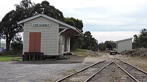
The Summit railway station
Appearance
 Northbound view in June 2015 | |
| General information | |
| Location | Granite Belt Drive, The Summit |
| Coordinates | 28°34′29″S 151°56′58″E / 28.574600°S 151.949543°E |
| Elevation | 923.5 metres (3,030 ft) |
| Owned by | Queensland Rail |
| Operated by | Traveltrain |
| Line(s) | Southern |
| Distance | 307 kilometres from Brisbane |
| Platforms | 1 |
| Tracks | 1 |
| Construction | |
| Structure type | Ground |
| Other information | |
| Status | Closed |
| History | |
| Opened | 3 March 1881 |
The Summit railway station is located on the Southern line in Queensland, Australia. It services the town of The Summit, a fruit growing district in the Granite Belt. At 923.5 metres (3,030 ft) above sea level, it is the highest station in the state.[1][2][3]
History
[edit]The Summit station opened on 3 March 1881, when the Queensland Railway's Southern line was extended from Warwick to Stanthorpe.[4] It was served by freight trains conveying apples for Golden Circle until 2007.[5]
References
[edit]- ^ "Upcoming events". Southern Downs Steam Railway. Archived from the original on 17 June 2016. Retrieved 13 May 2017.
- ^ "North Dalveen, Cottonvale, Thulimbah, The Summit + Applethorpe". Granite Belt Wine Country. Archived from the original on 11 June 2015. Retrieved 13 May 2017.
- ^ "The Summit – railway station (entry 34151)". Queensland Place Names. Queensland Government. Retrieved 13 May 2017.
- ^ "The Opening of the Stanthorpe Railway". The Brisbane Courier. Vol. XXXV, no. 7, 274. Queensland, Australia. 5 May 1881. p. 3 – via National Library of Australia.
- ^ "The Summit". When there were Stations. Archived from the original on 13 May 2017. Retrieved 13 May 2017.
External links
[edit] Media related to The Summit railway station at Wikimedia Commons
- The Summit When there were Trains gallery

