Jump to content

英文维基 | 中文维基 | 日文维基 | 草榴社区

Thomastown, Rhondda Cynon Taf

Coordinates: 51°34′30″N 3°26′15″W / 51.575090°N 3.43762°W / 51.575090; -3.43762
From Wikipedia, the free encyclopedia

Thomastown
Thomastown is located in Rhondda Cynon Taf
Thomastown
Thomastown
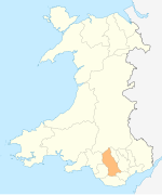
Location within Rhondda Cynon Taf
OS grid referenceST 0047 8723
Community
Principal area
Preserved county
CountryWales
Sovereign stateUnited Kingdom
Post townPorth
Postcode districtCF39
Dialling code01443
PoliceSouth Wales
FireSouth Wales
AmbulanceWelsh
UK Parliament
List of places
UK
Wales
Rhondda Cynon Taf
51°34′30″N 3°26′15″W / 51.575090°N 3.43762°W / 51.575090; -3.43762

Thomastown (Welsh: Tretomas) is a village and district of the large community of Tonyrefail, within Rhondda Cynon Taf, South Wales. It is located to the south of Tonyrefail within the 'Tonyrefail West' electoral ward, and falls within the Ely Valley along the A4119.

Thomastown is also a community ward for elections to Tonyrefail & District Community Council.[1]

References

[edit]
  1. ^ "Tonyrefail & District Community Council". Tonyrefail & District Community Council. Retrieved 25 June 2022.