Thong, Kent
Appearance
| Thong | |
|---|---|
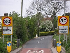
 Thong village boundary signs | |
Location within Kent | |
| OS grid reference | TQ673707 |
| District | |
| Shire county | |
| Region | |
| Country | England |
| Sovereign state | United Kingdom |
| Post town | Gravesend |
| Postcode district | DA12 |
| Police | Kent |
| Fire | Kent |
| Ambulance | South East Coast |
| UK Parliament | |
Thong is a hamlet southeast of Gravesend in Kent, England. The population of the hamlet is included in the civil parish of Shorne.
It has frequently been noted on lists of unusual place names[1] and appeared as a question answer for Round Britain Quiz on BBC Radio 4.[2]
The name 'Thong' is first attested in the Registrum Roffense of circa 1200, where it appears as Thuange. The name may correspond with the Middle Low German dwenge meaning 'trap', but this cannot be confirmed.[3]
References
[edit]- ^ Lyall, Sarah (22 January 2009). "No Snickering: That Road Sign Means Something Else". The New York Times. Retrieved 13 July 2014.
- ^ "Programme 8, 2015: North of England take on The Midlands". Round Britain Quiz. 7 December 2015. Radio 4.
- ^ Eilert Ekwall, The Concise Oxford Dictionary of English Place-names, p.466.


