Tortworth
| Tortworth | |
|---|---|
 | |
Location within Gloucestershire | |
| Population | 147 |
| OS grid reference | ST7093 |
| Civil parish |
|
| Unitary authority | |
| Ceremonial county | |
| Region | |
| Country | England |
| Sovereign state | United Kingdom |
| Post town | Wotton-under-Edge |
| Postcode district | GL12 |
| Police | Avon and Somerset |
| Fire | Avon |
| Ambulance | South Western |
| UK Parliament | |
Tortworth is a small village and civil parish, near Thornbury in Gloucestershire, England. It has a population of 147 as of 2011. It lies on the B4509 road, which crosses the M5 motorway to the west of Tortworth.[1]
History[edit]
In the Domesday Book of 1086 the manor is recorded as held by Turstin FitzRolf.[2] Tortworth is noted for its ancient chestnut tree in St. Leonard's churchyard, which became known as the "Great Chestnut of Tortworth" as early as 1150. This tree measured 51 feet in circumference at 6 feet from the ground in 1720.[3] The tree is one of fifty Great British Trees, selected in 2002 by The Tree Council to commemorate the Queen's Golden Jubilee.[4]
Geography[edit]
The Tortworth inlier is the most complete section of "Silurian" rocks in the Bristol and South Gloucestershire area.[5] Old red sandstone is most dominant.[6]
Notable landmarks[edit]

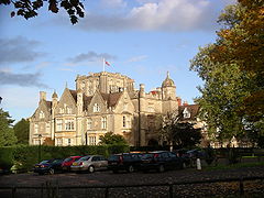
The civil parish contains Tortworth Court. It was formerly the home of the Earls of Ducie, but is now run as a hotel.[7][8] Tortworth Rectory, was part of Oriel College.[9] It was renowned for its library collection, which was eventually purchased by the Earls of Ducie.[10]
There is a national prison nearby, HM Prison Leyhill, which was converted into a prison from an army hospital in the post-war period.[11] In 1985 the prison won the Windlesham Trophy for the best-kept prison gardens.[12]
References[edit]
- ^ Google (29 August 2016). "Tortworth" (Map). Google Maps. Google. Retrieved 29 August 2016.
- ^ Williams, Ann; Martin, Geoffrey Haward (2003). Domesday Book: A Complete Translation. Penguin Books. p. 469. ISBN 978-0-14-051535-0.
- ^ Sylvan sketches; or, A companion to the park and the shrubbery, by the author of the Flora domestica. 1825. p. 96.
- ^ "Tortworth Sweet Chestnut". Woodland Trust. Retrieved 29 August 2016.
- ^ British Geological Survey 1:50,000 geological map sheet no 264 (England & Wales series) Bristol & 1" scale Bristol District:special sheet, BGS, Keyworth, Notts
- ^ Transactions Of The Geological Society. Cadell. 1824. p. 341.
- ^ The Gentleman's Magazine, and Historical Chronicle, for the Year ... Edw. Cave. 1853. p. 87.
- ^ Hospitality. Hotel, Catering and Institutional Management Association. 2003. p. 637.
- ^ Mabey, Richard (1986). Gilbert White: A Biography of the Author of The Natural History of Selborne. University of Virginia Press. p. 96. ISBN 978-0-8139-2649-0.
- ^ Ker, Neil Ripley; Perkin, Michael (2004). A Directory of the Parochial Libraries of the Church of England and the Church in Wales. Bibliographical Society. p. 373. ISBN 978-0-948170-13-3.
- ^ The British Journal of Delinquency. Institute for the Study and Treatment of Delinquency and Baillière, Tindall and Cox. 1951. p. 25.
- ^ GC & HTJ. Haymarket Publishing. 1985. p. 4.
External links[edit]
- Tortworth village website
- Tortworth, Andrew Plaster, Bristol & Avon Family History Society Journal, June 2007
- Tortworth Chestnut on Flickr
- St. Leonard's Church, Tortworth; CRoFTT benefice

