Tredegar Park, Newport
| Tredegar Park | |
|---|---|
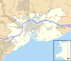
Location within Newport | |
| Population | 4,421 (2011 census)[1] |
| Language | English Cymraeg (Welsh) |
| OS grid reference | ST294852 |
| Principal area | |
| Country | Wales |
| Sovereign state | United Kingdom |
| Post town | NEWPORT |
| Postcode district | NP10 8 |
| Dialling code | 01633 Maesglas exchange |
| Police | Gwent |
| Fire | South Wales |
| Ambulance | Welsh |
| UK Parliament | |
| Senedd Cymru – Welsh Parliament | |
Tredegar Park (Welsh: Parc Tredegyr) is a community (civil parish) of the city of Newport. It is named after the nearby park, although the community covers a much smaller area.
Description
[edit]The community is bounded by the Ebbw River to the northeast, the Great Western Main Line to the east, Pencarn Lane to the south, and the grounds of Tredegar House to the northwest. It consists of the 1970s Duffryn estate and immediate surroundings. Many new private housing estates have been built around Duffryn.
Governance
[edit]Until 2022 Tredegar Park was the name of the electoral ward coterminous with the community, surrounded by the Marshfield ward to the south, west and east.[2] The ward elected one city councillor to Newport City Council.[3] Following an electoral boundary review, the ward was merged with Marshfield, to become Tredegar Park and Marshfield. Three councillors were elected at the May 2022 election.[4]
References
[edit]- ^ "Newport ward 2011". Retrieved 5 April 2015.
- ^ Election Maps, Ordnance Survey. Retrieved 22 September 2018.
- ^ "Council Election 2017: Newport nominations", Western Telegraph, 5 April 2017. Retrieved 22 September 2018.
- ^ "The key battlegrounds where the Newport council election could be won and lost". Wales Online. 27 April 2022. Retrieved 22 August 2022.

