
User:Mliu92/sandbox/Peninsula Commute template
< User:Mliu92 | sandbox
Southern Pacific Peninsula Commute | ||||||||||||||||||||||||||||||||||||||||||||||||||||||||||||||||||||||||||||||||||||||||||||||||||||||||||||||||||||||||||||||||||||||||||||||||||||||||||||||||||||||||||||||||||||||||||||||||||||||||||||||||||||||||||||||||||||||||||||||||||||||||||||||||||||||||||||||||||||||||||||||||||||||||||||||||||||||||||||||||||||||||||||||||||||||||||
|---|---|---|---|---|---|---|---|---|---|---|---|---|---|---|---|---|---|---|---|---|---|---|---|---|---|---|---|---|---|---|---|---|---|---|---|---|---|---|---|---|---|---|---|---|---|---|---|---|---|---|---|---|---|---|---|---|---|---|---|---|---|---|---|---|---|---|---|---|---|---|---|---|---|---|---|---|---|---|---|---|---|---|---|---|---|---|---|---|---|---|---|---|---|---|---|---|---|---|---|---|---|---|---|---|---|---|---|---|---|---|---|---|---|---|---|---|---|---|---|---|---|---|---|---|---|---|---|---|---|---|---|---|---|---|---|---|---|---|---|---|---|---|---|---|---|---|---|---|---|---|---|---|---|---|---|---|---|---|---|---|---|---|---|---|---|---|---|---|---|---|---|---|---|---|---|---|---|---|---|---|---|---|---|---|---|---|---|---|---|---|---|---|---|---|---|---|---|---|---|---|---|---|---|---|---|---|---|---|---|---|---|---|---|---|---|---|---|---|---|---|---|---|---|---|---|---|---|---|---|---|---|---|---|---|---|---|---|---|---|---|---|---|---|---|---|---|---|---|---|---|---|---|---|---|---|---|---|---|---|---|---|---|---|---|---|---|---|---|---|---|---|---|---|---|---|---|---|---|---|---|---|---|---|---|---|---|---|---|---|---|---|---|---|---|---|---|---|---|---|---|---|---|---|---|---|---|---|---|---|---|---|---|---|---|---|---|---|---|---|---|---|---|---|---|---|---|---|---|---|---|---|---|---|---|---|---|---|---|---|---|---|---|---|---|---|---|
| ||||||||||||||||||||||||||||||||||||||||||||||||||||||||||||||||||||||||||||||||||||||||||||||||||||||||||||||||||||||||||||||||||||||||||||||||||||||||||||||||||||||||||||||||||||||||||||||||||||||||||||||||||||||||||||||||||||||||||||||||||||||||||||||||||||||||||||||||||||||||||||||||||||||||||||||||||||||||||||||||||||||||||||||||||||||||||
| ||||||||||||||||||||||||||||||||||||||||||||||||||||||||||||||||||||||||||||||||||||||||||||||||||||||||||||||||||||||||||||||||||||||||||||||||||||||||||||||||||||||||||||||||||||||||||||||||||||||||||||||||||||||||||||||||||||||||||||||||||||||||||||||||||||||||||||||||||||||||||||||||||||||||||||||||||||||||||||||||||||||||||||||||||||||||||
This is a route-map template for the Peninsula Commute in the San Francisco Bay Area.
- For information on using this template, refer to Wikipedia:Route diagram template.
- For pictograms used, see Wikimedia Commons: BSicon/Catalogue.
References[edit]
- 1879: Chandler, Samuel C. (1973). "19: Railroads". Gateway to the Peninsula: A History of the City of Daly City, San Mateo County, California (PDF). Daly City, California: The City of Daly City. p. 76. LCCN 73-86870. Retrieved 20 July 2016.
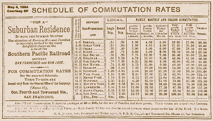
- 1884: "Schedule of Commutation Rates". wx4's Dome of Foam. Southern Pacific. 4 May 1844. Retrieved 20 July 2016.
- 1899: Southern Pacific System: List of Officers, Agencies and Stations (PDF). Southern Pacific. 1899. Retrieved 20 July 2016.
- 1899: "Coast Division: Time Schedules of Passenger Trains: Monterey Line—Broad Gauge" (PDF). wx4's Dome of Foam. Southern Pacific. 25 June 1899. Retrieved 20 July 2016.
- 1907: "Bay Shore Cutoff Trains To Be Numerous". San Francisco Call. Vol. 102, no. 121. 29 September 1907. Retrieved 15 January 2017.
- 1938: Southern Pacific (5 May 1938). wx4 (ed.). "Southern Pacific Time Tables: San Francisco, So. San Francisco, Burlingame, San Mateo, Redwood City, Palo Alto, Mayfield, San Jose, Los Altos, Los Gatos" (PDF). wx4's Dome of Foam. Retrieved 18 July 2016.
{{cite web}}: CS1 maint: numeric names: editors list (link) - 1953: Southern Pacific (27 September 1953). mpar21 (ed.). "Southern Pacific Time Tables: San Francisco, So. San Francisco, Burlingame, San Mateo, Redwood City, Palo Alto, California Avenue, San Jose, Los Altos, Los Gatos". flickr. Retrieved 18 July 2016.
{{cite web}}: CS1 maint: numeric names: editors list (link) - 1958: Southern Pacific (28 September 1958). Jafafa Hots (ed.). "Southern Pacific Time Tables: San Francisco, So. San Francisco, Burlingame, San Mateo, Redwood City, Palo Alto, California Avenue, San Jose, Los Altos, Los Gatos". flickr. Retrieved 18 July 2016.
- 1968: Southern Pacific (12 May 1968). wx4 (ed.). "Southern Pacific PENINSULA Time Tables: San Francisco, So. San Francisco, Burlingame, San Mateo, Redwood City, Palo Alto, California Avenue, San Jose, Los Gatos". wx4's Dome of Foam. Retrieved 18 July 2016.
{{cite web}}: CS1 maint: numeric names: editors list (link) - 1973: Southern Pacific (22 December 1953). mpar21 (ed.). "Southern Pacific PENINSULA Time Tables: San Francisco, So. San Francisco, Burlingame, San Mateo, Redwood City, Palo Alto, California Avenue, San Jose". flickr. Retrieved 18 July 2016.
{{cite web}}: CS1 maint: numeric names: editors list (link) - 1976: "Southern Pacific PENINSULA Time Tables: San Francisco, So. San Francisco, Burlingame, San Mateo, Redwood City, Palo Alto, California Avenue, San Jose and intermediate stations". Espee Railfan. 1 May 1976. Retrieved 7 July 2016.
- 1978: "Southern Pacific PENINSULA Time Tables: San Francisco, So. San Francisco, Burlingame, San Mateo, Redwood City, Palo Alto, California Avenue, San Jose and intermediate stations". Rails Around the Bay. 1 April 1978. Archived from the original on 1 July 2007. Retrieved 7 July 2016.