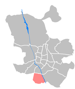
Villaverde (Madrid)
Villaverde | |
|---|---|
 | |
| Country | Spain |
| Auton. community | Madrid |
| Municipality | Madrid |
| Government | |
| • Councillor-President | Orlando Chacón Tabares (PP, 2023) |
| Area | |
• Total | 20.29 km2 (7.83 sq mi) |
| Population | 126,802 |
| • Density | 6,249/km2 (16,180/sq mi) |
| Madrid district number | 17 |
 | |
Villaverde is one of the 21 districts of the city of Madrid, Spain.
Geography and history
[edit]The municipality was absorbed by Madrid in the 1950s as a result of the plans that the Franco government made to simplify the structure of big city administrations. Since then, is a district. It was in those years when it experimented a massive growth caused by the rural flight in Spain. This is the reason that made Villaverde a typical working class neighbourhood.
The Barreiros automobile company set up its industrial factory in 1951, which attracted thousands of workers. In 1978 it was absorbed by the French company Peugeot.
This condition leaves a heavy footprint in the district, because it has conditioned the current population composition, with many retired people (some of them returning to their towns in Andalusia, Castile-León, ...) and immigrants attracted by the cheap housing prices.
The district is administratively divided into five wards (barrios):
External links
[edit]![]() Media related to Villaverde District at Wikimedia Commons
Media related to Villaverde District at Wikimedia Commons
