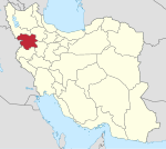
Emam District
Appearance
Emam District
Persian: بخش امام | |
|---|---|
| Coordinates: 36°03′01″N 46°36′59″E / 36.05028°N 46.61639°E[1] | |
| Country | Iran |
| Province | Kurdistan |
| County | Saqqez |
| Capital | Santeh |
| Population (2016)[2] | |
• Total | 12,946 |
| Time zone | UTC+3:30 (IRST) |
Emam District (Persian: بخش امام) is in Saqqez County, Kurdistan province, Iran. Its capital is the city of Santeh.[3]
History
[edit]After the 2011 National Census, Emam, Khvor Khvoreh, and Tilakuh Rural Districts were separated from Ziviyeh District in the formation of Emam District.[3] In 2019, the village of Santeh was elevated to the status of a city.[4]
Demographics
[edit]Population
[edit]At the time of the 2016 census, the district's population was 12,946 inhabitants in 3,358 households.[2]
| Administrative Divisions | 2016[2] |
|---|---|
| Emam RD | 3,658 |
| Khvor Khvoreh RD | 5,217 |
| Tilakuh RD | 4,071 |
| Santeh (city)[a] | |
| Total | 12,946 |
| RD = Rural District | |
See also
[edit]Notes
[edit]References
[edit]- ^ OpenStreetMap contributors (29 December 2024). "Emam District (Saqqez County)" (Map). OpenStreetMap (in Persian). Retrieved 29 December 2024.
- ^ a b c Census of the Islamic Republic of Iran, 1395 (2016): Kurdistan Province. amar.org.ir (Report) (in Persian). The Statistical Center of Iran. Archived from the original (Excel) on 8 May 2022. Retrieved 19 December 2022.
- ^ a b "Santeh of Saqqez County was promoted to a city". javanonline.ir (in Persian). Ministry of the Interior. 15 March 2018. Archived from the original on 29 December 2024. Retrieved 29 December 2024 – via Young News Agency.
- ^ a b "Santeh of Saqqez County was upgraded to a city". farsnews.ir (in Persian). 13 March 2019. Archived from the original on 22 January 2024. Retrieved 22 January 2024 – via Fars Media Corporation.


