
Phnom Krom
This article relies largely or entirely on a single source. (April 2021) |
| Phnom Krom | |
|---|---|
| ភ្នំក្រោម | |
 View of Phnom Krom at dawn | |
| Highest point | |
| Elevation | 140 m (460 ft) |
| Coordinates | 13°17′09″N 103°48′44″E / 13.28573°N 103.81218°E[1] |
| Geography | |
 Phnom Krom Location of Phnom Krom in Cambodia | |
| Location | Siem Reap Province, Cambodia |
| Geology | |
| Mountain type | Sandstone |
| Climbing | |
| Easiest route | Drive, then hike |
Phnom Krom (Khmer: ភ្នំក្រោម, lit. "downstream hill") is a 140 m high hill close to Siem Reap city, Cambodia. There is a temple on the top which derived its name from the hill, Prasat Phnom Krom (Khmer: ប្រាសាទភ្នំក្រោម).
Location[edit]
Phnom Krom is about 12 kilometers southwest of Siem Reap town.
Phnom Krom hill is very rocky; local legend has it that the rocks were exposed by the monkey general Hanuman during a hunt for medicine in the Ramayana epic. The area beyond the temple’s west gate affords views of the Tonle Sap lake.
Phnom Krom railway[edit]
Phnom Krom was at the southern end of the Phnom Krom railway, a narrow-gauge French colonial railway that was most likely constructed to take stone from the now-defunct quarries on Phnom Krom to Siem Reap.
Gallery[edit]
-
 Tonle Sap lake and Phnom Krom hill
 -
 Tonle Sap lake and Chong Kneas village viewed from Phnom Krom hill
 -
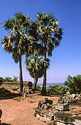 Sugar palm trees on the hill


See also[edit]
References[edit]
External links[edit]
 Media related to Phnom Krom at Wikimedia Commons
- Nick Ray, Cambodia
