Sarız
Sarız | |
|---|---|
District and municipality | |
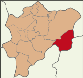
 Map showing Sarız District in Kayseri Province | |
| Coordinates: 38°28′45″N 36°30′2″E / 38.47917°N 36.50056°E | |
| Country | Turkey |
| Province | Kayseri |
| Government | |
| • Mayor | Baki Bayrak (MHP) |
Area | 1,173 km2 (453 sq mi) |
| Population (2022)[1] | 9,282 |
| • Density | 7.9/km2 (20/sq mi) |
| Time zone | UTC+3 (TRT) |
| Area code | 0352 |
| Website | www |
Sarız, formerly known as Sáros (Greek: Σάρος), is a municipality and district of Kayseri Province, Turkey.[2] Its area is 1,173 km2,[3] and its population is 9,282 (2022).[1] The mayor is Baki Bayrak (MHP).
History
[edit]The history of the district goes back to ancient times, to 700 BC. Cilicia remained under the rule of Dulkadiroğulları Principality from Byzantine Empire and beylik, and was included in Ottoman Empire in the period of Yavuz Sultan Selim in 1515. The settlement, which was shown as a part of the Hurman district of the Elbistan district in the 16th century Ottoman records, was connected to the Aziziye district, which was created in 1861. registered as a sub-district. During this period, the center of Sariz was called "Koyyeri". In the records of 1910, it is stated that Sarız, which is a township, has 46 villages. The Municipality organization was established on July 30, 1914, upon the request of the Sivas Governor of the time being approved by the Ottoman Ministry of Internal Affairs. In 1927, it was separated from Sivas and connected to Kayseri. In 1946, it was separated from the Pınarbaşı district to which it was affiliated and became an independent district.[4]
Composition
[edit]There are 44 neighbourhoods in Sarız District:[5]
- Akoluk
- Altısöğüt
- Avşarobası
- Ayranlık
- Bahçeli
- Büyükörtülü
- Büyüksöbeçimen
- Çağşak
- Çatalpınar
- Çavdar
- Çörekdere
- Dallıkavak
- Damızlık
- Darıdere
- Dayoluk
- Değirmentaş
- Fettahdere
- Gümüşali
- Günesen
- İncedere
- İncemağara
- Karapınar
- Karayurt
- Kemer
- Kırkısrak
- Kıskaçlı
- Kızılpınar
- Küçükkabaktepe
- Küçükörtülü
- Küçüksöbeçimen
- Kurdini
- Kurudere
- Kuşçu
- Mirzaağa
- Mollahüseyinler
- Oğlakkaya
- Ördekli
- Sancakağıl
- Tavlaköy
- Tekneli
- Yaylacı
- Yedioluk
- Yeni
- Yeşilkent
Climate
[edit]Sarız has a dry-summer continental climate (Köppen: Dsb).[6] Summers are dry, with warm days and cool nights, and winters are cold.
| Climate data for Sarız (1991–2020) | |||||||||||||
|---|---|---|---|---|---|---|---|---|---|---|---|---|---|
| Month | Jan | Feb | Mar | Apr | May | Jun | Jul | Aug | Sep | Oct | Nov | Dec | Year |
| Mean daily maximum °C (°F) | 1.5 (34.7) |
2.7 (36.9) |
7.2 (45.0) |
13.3 (55.9) |
18.3 (64.9) |
23.2 (73.8) |
27.8 (82.0) |
28.5 (83.3) |
24.2 (75.6) |
17.9 (64.2) |
10.1 (50.2) |
4.1 (39.4) |
15.0 (59.0) |
| Daily mean °C (°F) | −4.0 (24.8) |
−2.9 (26.8) |
1.6 (34.9) |
6.9 (44.4) |
11.3 (52.3) |
15.4 (59.7) |
19.3 (66.7) |
19.5 (67.1) |
15.1 (59.2) |
9.7 (49.5) |
3.1 (37.6) |
−1.7 (28.9) |
7.8 (46.0) |
| Mean daily minimum °C (°F) | −8.8 (16.2) |
−7.9 (17.8) |
−3.3 (26.1) |
0.9 (33.6) |
4.3 (39.7) |
7.0 (44.6) |
9.5 (49.1) |
9.7 (49.5) |
5.9 (42.6) |
2.4 (36.3) |
−2.7 (27.1) |
−6.5 (20.3) |
0.9 (33.6) |
| Average precipitation mm (inches) | 48.61 (1.91) |
44.92 (1.77) |
57.54 (2.27) |
56.52 (2.23) |
58.76 (2.31) |
31.9 (1.26) |
8.59 (0.34) |
8.88 (0.35) |
16.1 (0.63) |
43.72 (1.72) |
48.3 (1.90) |
54.15 (2.13) |
477.99 (18.82) |
| Average precipitation days (≥ 1.0 mm) | 7.8 | 8.1 | 9.3 | 8.6 | 9.3 | 5.2 | 2.1 | 2.1 | 2.8 | 5.8 | 5.9 | 8.0 | 75.0 |
| Average relative humidity (%) | 70.2 | 69.1 | 65.9 | 61.5 | 61.4 | 56.4 | 48.7 | 49.0 | 51.7 | 60.8 | 64.8 | 70.3 | 60.9 |
| Source: NOAA[7] | |||||||||||||
References
[edit]- ^ a b "Address-based population registration system (ADNKS) results dated 31 December 2022, Favorite Reports" (XLS). TÜİK. Retrieved 19 September 2023.
- ^ Büyükşehir İlçe Belediyesi, Turkey Civil Administration Departments Inventory. Retrieved 19 September 2023.
- ^ "İl ve İlçe Yüz ölçümleri". General Directorate of Mapping. Retrieved 19 September 2023.
- ^ ""Settlement and Population in Sariz (1865-1945)" Erciyes University Journal of Social Sciences Institute Issue:38, P:19-39, Year: 2015/1" (PDF). Archived from the original (PDF) on April 13, 2016. Retrieved March 31, 2016.
- ^ Mahalle, Turkey Civil Administration Departments Inventory. Retrieved 19 September 2023.
- ^ "Table 1 Overview of the Köppen-Geiger climate classes including the defining criteria". Nature: Scientific Data.
- ^ "World Meteorological Organization Climate Normals for 1991-2020 — Sarız". National Oceanic and Atmospheric Administration. Retrieved January 17, 2024.
External links
[edit]- Sarız District Governorship Official WebsiteArchived April 2, 2006, at the Wayback Machine
- Kayseri Governorship Official Websiteen/ Archived April 6, 2006, at the Wayback Machine
- Sarız District WebsiteArchived February 26, 2020, at the Wayback Machine


