Trstena (Vranje)
Appearance
Trstena
Трстена (Serbian) | |
|---|---|
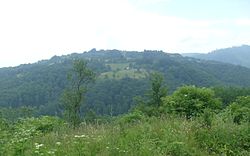
 Village's landscape | |
 | |
| Coordinates: 42°40′47″N 21°46′07″E / 42.67972°N 21.76861°E | |
| Country | |
| District | Pčinja District |
| Municipality | Vranje |
| Area | |
• Total | 15.29 km2 (5.90 sq mi) |
| Elevation | 823 m (2,700 ft) |
| Population (2011)[2] | |
• Total | 43 |
| • Density | 2.8/km2 (7.3/sq mi) |
| Time zone | UTC+1 (CET) |
| • Summer (DST) | UTC+2 (CEST) |
Trstena is a village located in the municipality of Vranje, Serbia. According to the 2011 census, the village has a population of 43 people.[2]
References
[edit]- ^ "Насеља општине Врање" (pdf). stat.gov.rs (in Serbian). Statistical Office of Serbia. Retrieved 7 November 2019.
- ^ a b "COMPARATIVE OVERVIEW OF THE NUMBER OF POPULATION IN 1948, 1953, 1961, 1971, 1981, 1991, 2002 AND 2011" (pdf). stat.gov.rs. Statistical Office of Serbia. Retrieved 7 November 2019.
