Umboi Island
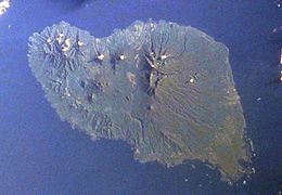
 Space Shuttle image of Umboi Island (north to upper right) | |
 Umboi Island is to the west of New Britain | |
| Geography | |
|---|---|
| Coordinates | 5°32′S 147°52′E / 5.533°S 147.867°E |
| Archipelago | Bismarck Archipelago |
| Area | 930 km2 (360 sq mi) |
| Highest elevation | 1,335 m (4380 ft) |
| Highest point | Mount Talo |
| Administration | |
Papua New Guinea | |
| Province | Morobe Province |
| LLG | Siassi Rural LLG |
Umboi (also named Rooke or Siassi) is a volcanic island between the mainland of Papua New Guinea and the island of New Britain. It is separated from New Britain by the Dampier Strait, and Huon Peninsula and New Guinea by the Vitiaz Strait. It has an elevation of 1,335 metres (4,380 feet).
The Siassi Archipelago lies off the southeast coast of Umboi Island (a total of 18 islands, only seven are inhabited).
History
[edit]During the mid-1920s, the population of the Siassi Islands was a little over 700 people. It had more than doubled (to almost 1700 people) by the early 1960s, and then decreased to a little more than 1600 people by the early 1980s.
In 1936 a Lutheran mission was established on the island which was headed by Pastor P.H Freund. in 1940 Freund was recruited by Lt. Commander Eric Feldt of the Royal Australian Navy to act as a Coastwatcher.[1]
During 1943 the island was briefly occupied by 500 Japanese troops from the 51st Reconnaissance Regiment which was commanded by Col. Jiro Sato. By early December 1943, after several allied bombing runs, the Japanese withdrew from the island.[1]
Inhabitants
[edit]The Siassi support themselves through traditional trade based on a barter system; they are important middlemen who deliver pigs, pots and ornate wooden bowls by sea in their canoes.[2] The people of the Siassi islands continue to believe in witchcraft and consider it to be the root cause of unfortunate events such as illness or crop failure.[3][4] The regional word for witchcraft is sanguma and the accused are often murdered.[4]
Buildings
[edit]A majority of the buildings on the Siassi islands are constructed using vernacular architecture.[2]
Languages
[edit]Languages are Papuan Kovai; and Austronesian: Mbula, Karanai, and Saveng languages.[5]

Volcano
[edit]The volcano is described as a complex Holocene volcano and has no recorded eruptions.[6]
Folklore
[edit]Local folklore claims that a large bioluminescent winged creature, referred to as a Ropen, can be observed flying around the skies of this and other surrounding islands.[7] Modern Cryptozoologists are still searching for this creature and no definitive evidence has ever been discovered.[8]
See also
[edit]References
[edit]- ^ a b Freund, A. P. H. (1989). Missionary turns spy: Pastor A.P.H. Freund's story of his service with the New Guinea Coast Watchers in the war against Japan, 1942-43. Lutheran Homes Inc. ISBN 0-7316-7045-0. OCLC 29320154.
- ^ a b The Influence of Overseas Trade on Housing Quality Among the Siassi of Papua New Guinea
- ^ "Siassi Island Diary (Part 2: Discussions of "sanguma")". PH SPOT. 2018-08-15. Retrieved 2023-04-06.
- ^ a b "The 'black magic' belief behind a rising number of murders in PNG". ABC News. 2018-01-21. Retrieved 2023-04-06.
- ^ Dutton, Tom; Tryon, Darrell T. (2010-12-14). Language Contact and Change in the Austronesian World. Walter de Gruyter. ISBN 978-3-11-088309-1.
- ^ "Umboi". Volcano World. 2011-08-28. Retrieved 2023-04-05.
- ^ Whitcomb, Jonathan David (2007). Searching for Ropens : living pterosaurs in Papua New Guinea. Livermore, CA: WingSpan Press. ISBN 9781595941534. OCLC 1153476698.
- ^ Naish, Darren (2016). Hunting monsters : cryptozoology and the reality behind the myths. Cork. ISBN 978-1-78428-191-5. OCLC 954131611.
{{cite book}}: CS1 maint: location missing publisher (link)
- "Umboi". Global Volcanism Program. Smithsonian Institution. Retrieved 2021-06-25.
