
User:Dave-okanagan/sandbox

You can help expand this article with text translated from the corresponding article in Japanese. (February 2021) Click [show] for important translation instructions.
|
| Mount Ōmuro | |
|---|---|
| 大室山 | |
_20100426.jpg) Mount Ōmuro seen from the west. | |
| Highest point | |
| Elevation | 580 m (1,900 ft)[1] |
| Coordinates | 34°54′11″N 139°5′40″E / 34.90306°N 139.09444°E |
| Geography | |
| Location | Itō, Shizuoka Prefecture, Japan |
| Geology | |
| Mountain type | Cinder cone[2] |
| Last eruption | about 4000 years ago[2] |
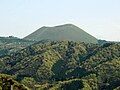
Mount Ōmuro (大室山, Ōmuroyama) is a 580 m (1,900 ft)-high cinder cone volcano in the Izu-Tobu volcano field of Itō, Shizuoka, Japan. The yearly mountain grass burning "Yamayaki" that been performed for more than 700 years is carried out in the early spring,[3] so it is often covered with annual plants and is a symbol of Itō. The mountain is designated as a Natural Monument and is part of Fuji-Hakone-Izu National Park.
Formation[edit]
Mt. Ōmuro is a scoria cone, a monogenetic volcano that erupted about 4000 years ago as one of the activities of the eastern Izu volcano group. Previously it was thought 5000 years ago, but a tree buried in volcanic ash was found at a construction site, and carbon dating has given the earlier date.

The scoria cone, crater from magma was Deki up jetted scoria (dark stone among those porous in bulk) is accumulated around the crater, frustoconical is obtained by forming a hill. The bottom diameter is 1000m, rising up 300 meters and narrowing to 250m across the rim. The bowl shaped crater is 40m deep. Approximately halfway down the south slope is a small 50m crater.The highest point is on the crater's south edge where there is a Triangulation station. Ōmuro is from the state of preservation and the well-equipped appearance, many also be introduced as one of the representative examples of the scoria cone in Japan. It was designated as a Natural Monument in 2010 August 5 [4]
Eruption and impact[edit]
.jpg)
The eruption of Mt. Ōmuro is believed to last less than 10 years, with several years off on the way . As the eruption progressed and the scoria cone grew, the first lava flow sprang up from the western foothills and flowed in two directions. The one that flowed to the south dammed a deep canyon and created a lake in the current pond area . This lake was transformed into a paddy field by digging a drainage tunnel during the Meiji era . Later 30 times as much lava overflowed from the two foothills in the northeast and south, and the lava that flowed to the southeast reclaimed Sagami Nada, creating the Jogasaki coast. At the same time, it also created a gentle land, which was later noticed by humans, and developed the tourist and villa areas of the Izu Kogen. The lava that flowed to the north filled the valley and created a lake there as well, and also flowed into Lake Ippeki a little, creating the small Twelve Islands. At the two craters in the northeast and south, the viscosity of the lava increased as the end of the eruption approached , creating a lava dome to cover the crater . On the other hand, a lava lake was created in the crater at the top of the mountain and then disappeared . After a while, leaving a crater of trace causing a small explosion from the southern slopes of scoria cone, eruption of Ōmuro was over all . The possibility that Mt. Ōmuro will erupt again is denied due to the characteristics of the monogenetic volcanoes .

Tourism[edit]
There is a chair lift (fee) from the northern foot of the mountain, reaching the summit in about 6 minutes. A walkway is maintained to go around the bowl on the crater's edge. It used to be possible to climb on foot, but it is now banned. The bottom of the crater has long been used as a tourist archery field. Around Mt. Ōmuro, tourist facilities on the Izu Kogen such as Sakura no Sato Park and Izu Cactus Park, as well as residential land and villas, spread out.
View[edit]
Izu Peninsula east coast and Mount Amagi , as well, if weather conditions are aligned, north Southern Alps from Mount Fuji , Hakone up to the mountains, to the south from the east Izu Oshima , including the Izu Islands, in the distance Miura Peninsula from the Boso Peninsula, You can even see the Tokyo Skytree.
Yamayaki[edit]

Yamayaki of Mt. Ōmuro was an event to grow good quality kaya that has been passed down for more than 700 years. The thatch grass collected at Mt. Ōmuro was used as a material for roofing, cattle and horse feed, compost, and charcoal bales, and was shipped not only locally but also to Edo (Tokyo). When the demand for kaya declined after the war, the open grass burning declined also, and the nearby Cactus Park led as a sightseeing event from 1960. The Yamayaki Preservation Society was established in 1980 to take over the event. Tourists can also participate in the ignition for a fee on a first-come, first-served basis. Yamayaki is scheduled for the second Sunday of February every year. As a preparation, in the fall of the previous year, the grass on the boundary of the mountain burning is cut and burned to create a 5 meter firebreak. On the day of the implementation, the crater will be "potted" in the morning. From noon, "all-mountain burning" is performed on the outside of the mountain. A fire is lit from the western foot of the mountain, and the fires that travel north and south of the mountain meet in the east. Burning may be postponed depending on the weather and the dryness of the mountain. In 2014 the burning was carried out on March 9, one month late due to the heavy snowfall.
Sakura no Sato[edit]

See " Sakura no Sato " for details. A park at the northwestern foot of the mountain is one of Japan's Top 100 Cherry Blossom Spots. Thousands of cherry blossoms of about 40 species are planted in 40,000 m², and it is devised so that you can enjoy the cherry blossoms from September to June of the following year. The Izu-Kogen Sakura no Sato Festival is held in early April, at the park.
Shrine / Stone Buddha[edit]
*Omuroyama Asama Shrine [17] --A shrine on the eastern side of the crater. Iwanaga Hime no Mikoto is the only deity . It is worshiped as a god of easy delivery and marriage. At Asama Shrine , whose main deities are Asama Okami and Konohanasakuya Bime , it is rare to worship Iwanagahime . [18] Kibana Noriyuki Saku毘売night of the sister of Panji Osahime life and sister,瓊people Kineinochi but married at the same time (Niniginomikoto), the ugly sister of God was sent back [19] . Like Mt. Ōmuro , Kumomi Sengen Shrine on Mt. Eboshi ( Matsuzaki-cho, Kamo-gun, Shizuoka Prefecture ), which is an independent peak overlooking Mt. Fuji, which enshrines the sister god, also enshrines the sister god.
*Gochi Nyorai Jizoson [20] --Five Buddhist statues built in the Edo period on the west side of the crater rim. Worshipers come to pray for marriage and safe delivery. In 1663 Kiyobei Amimoto [21] of Sagami Kuni Iwamura (now Manazuru, Kanagawa) prayed for his 9-year-old daughter at Omuroyama Asama Shrine, and as a thank-you the statue of Gochi Nyorai [22] was built . It is made of Manazuru stone and carried from Futo Harbor.
*Yatsugatake Jizo [23] - 8 statues on the south edge. It was built by fishermen who used Mt. Ōmuro as a landmark to pray for maritime safety and abundant fishing. There are old and new, and the one in the foreground was made in 1984 with a donation from the residents of Ike Ward, Ito.


Gallery[edit]
-
 From the northwest.
 -
 Symbolic pyroclastic cone of the Izu-Tobu volcano field.
 -
 Looking up from the north foot.
_20100426_(B).jpg)


External links[edit]
- The story of the land of Izu pages 82-87 in Japanese - Masato Koyama , Shizuoka University
- Mount Ōmuro Geosite - Izu Peninsula Geopark
- Mount Ōmuro Geosite - Japanese site differs from above.
References[edit]
- ^ "Mount Omuro, Japan". Peakbagger.com. Retrieved 2021-02-21.
- ^ a b 出典 : 大室山ジオサイト - 伊豆半島ジオパーク、2016年1月閲覧
- ^ 「山に炎 伊豆に春」『読売新聞』朝刊2020年2月25日(社会面)2020年2月29日閲覧
- ^ Agency for Cultural Affairs database 2021-08-16
Category:Mountains of Shizuoka Prefecture
Category:Fuji-Hakone-Izu National Park
Category:Volcanoes of Shizuoka Prefecture